A hiking guide by Kraig Adams · Dolomites, Italy
Alta Via 1
Plan the route. Book the huts. Know what each day holds.
A practical Alta Via 1 guide for hikers planning their own trip through the Dolomites. Bring your route, overnight stops and budget together, then take the daily notes and recordings with you. Based on my September 2025 hike.
The paid edition is being prepared. Sales open here when it’s ready.
Read Day 1 freeAlready bought the website edition? Open your guide
$19 USD · One-time purchase · No subscription · Applicable tax shown at checkout

- My trip
- 7 days / 6 nights
- Recorded distance
- 121.6 km / 75.6 mi
- Another pace
- 12-day planning option
- Offline companion
- 48-page PDF
Inside the guide
One purchase. The plan and the files to take with you.
A route that fits your pace
My seven-day itinerary and a twelve-day planning option, with route variants explained. See where a shorter day changes your overnight stops before you start booking.
Seven daily planning references
Route, terrain, timing, food and water, overnight details and alternatives when plans change. Eleven maps show the recorded route, daily elevation profiles and key route choices.
Your hut bookings and budget
Hut contacts, booking notes and an illustrative budget, plus separate seven-day and twelve-day worksheets. Put your actual dates, confirmations and costs in one place and save a copy.
Website reader and offline downloads
The full guide with my trip account and photographs, a 48-page PDF and seven original daily GPX recordings, available individually or in one ZIP. Download before you leave phone service.
Read a day from the guide · No email needed
Day 1 · Lago di Braies to Pederü
This is the opening stage of my seven-day trip. The map and planning reference below are taken directly from the full guide. Use them to see the level of detail before you buy.
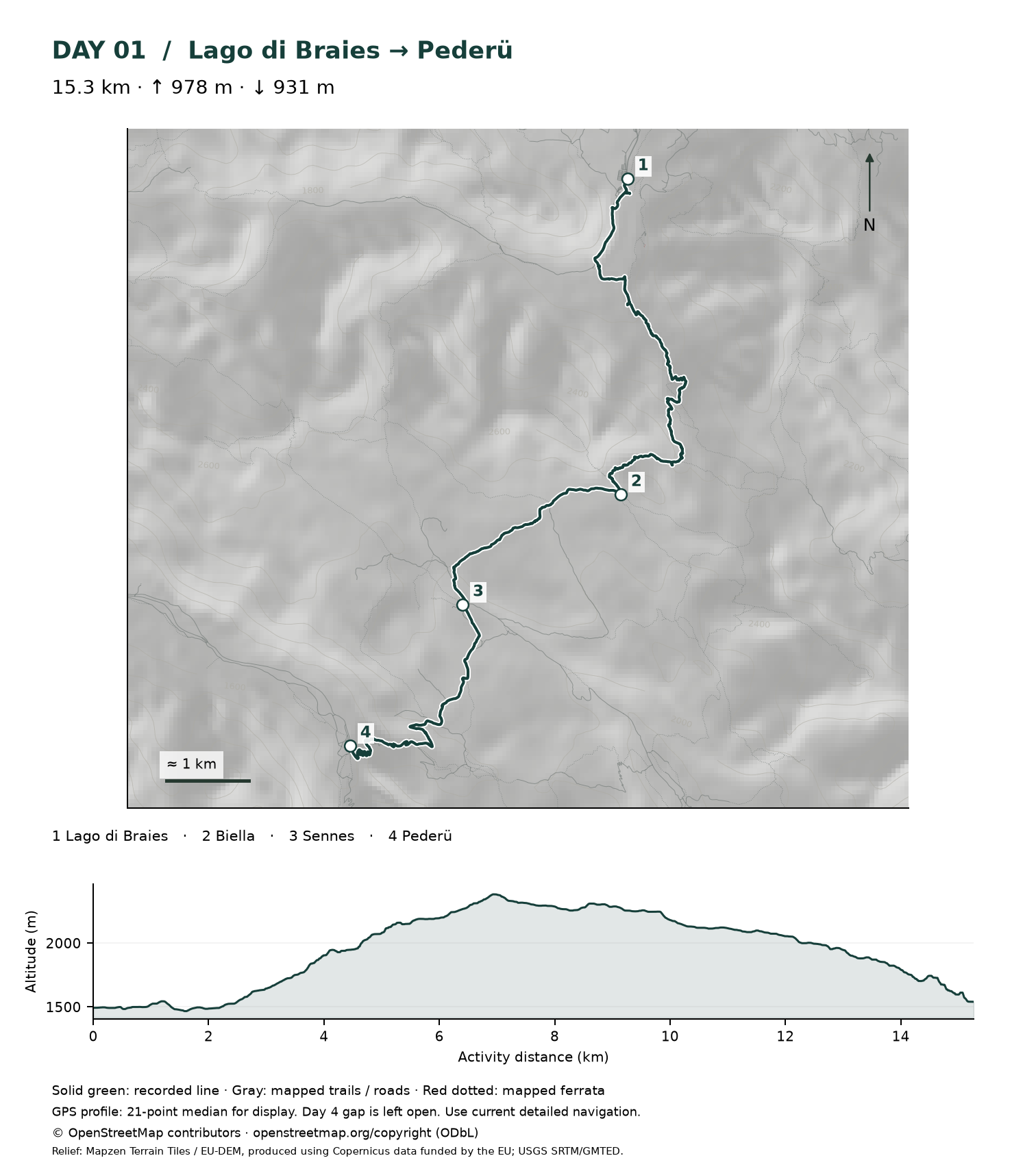
My September 2025 recording is a planning reference. Walking times describe my trip; choose your own pace and use current detailed navigation.
Maps: © OpenStreetMap contributors, ODbL. Relief: Mapzen Terrain Tiles / EU-DEM, produced using Copernicus data funded by the EU; USGS SRTM/GMTED. Map source data.
Plan this stage
Activity: 15.3 km · 978 m ascent · 931 m descent. Moving 3h 36m; elapsed 5h 00m.
Recorded times describe my September 2025 hike. Allow for your pace, breaks and current conditions. Source activity
- Route to understand
- Braies lake — Biella — Sennes — Pederü. The recording follows trail 1 to Biella, then the Sennes connection and the 7/7A descent to Pederü.
- Terrain and effort
- A substantial climb from the lake, followed by a long descent. Starting at a famous lake does not make this a gentle opening day.
- Time to allow
- The tourism route to Biella alone is 6.2 km (3.9 mi), with 954 m (3,130 ft) of ascent. Its description allows about 3½ hours. That is only the first part of my day.
- Food and drinking water
- Biella at about 7.3 km and Sennes at about 10.4 km are the recorded support points before Pederü. I ate at Biella in 2025. Confirm current food service and potable refill or bottled-water availability; carry enough to reach the next confirmed stop.
- Tonight
- Pederü. Quote a one-night stay and dinner explicitly; see its individual meal-plan terms in the hut directory.
- If the plan changes
- For a shorter opening day, book Biella and rebuild the next stage to Fanes. Pederü is a road access point; onward transport still needs arranging.
Before you leaveIf my lake transfer runs late, is reaching Pederü before its arrival deadline realistic?
Sources: Three Peaks tourism: Braies to Biella · Cortina tourism: Biella to Fanes · Pederü: provider information · Braies access and lake buses · OpenStreetMap: mapped trail geometry
The hut directory and booking worksheets referenced here are included in the full guide. Provider information was checked on 12 September 2026; confirm details for your dates.
Continue through the Dolomites
The full edition includes all seven stages, the twelve-day option, hut planning and the PDF and GPX downloads.
Before you buy
Is this the guide for your trip?
For independent hikers arranging their own hut-to-hut journey, with enough mountain experience to assess the terrain and choose a suitable pace. My seven days are a demanding worked example. The twelve-day option allows shorter stages and more time for photography; I have not stayed at every additional hut.
The covered journey starts at Lago di Braies and finishes at the road below Bianchet, with onward travel toward Belluno. Add arrival and departure days to your walking schedule. You arrange your own bookings; personal trip support and reservations are not included.
The maps and recordings are planning references. Bring detailed offline navigation and check current trail conditions. The Tissi recording gap remains open, and the final bus boarding connection needs a local check. Current tariffs and transport details must be confirmed for your dates.
Edition updated 12 September 2026. Your purchase includes this edition. Future editions and a fixed update schedule are not promised.
How access works
- Buy the website edition once through secure Stripe checkout.
- Return here after payment to open the full guide and downloads.
- Keep the access code on your emailed invoice. Use it to reopen your guide on your phone or another computer.
Can I buy it on Gumroad instead?
Yes. The original Gumroad edition remains available as a separate purchase, with its own contents and price. Gumroad purchases stay in your Gumroad library; they do not automatically unlock this website edition.
Do I need another account?
No additional password is needed on this website. Your access code opens the guide on each device. Keep the code private. This browser stays unlocked for up to 30 days; you can sign out at any time.
Will it work without an internet connection?
The website needs a connection to verify access. Download the PDF, GPX files and your worksheet before hiking. Save detailed offline maps in your chosen navigation app separately.
What if I need help or a refund?
Contact kraig@kraigadams.com for a missing file or access problem. Your receipt identifies your website purchase. Email me if you need help with a refund request. A refunded or reversed purchase no longer unlocks the website.
Alta Via 1 · Website edition
Start putting your trip together.
$19 USD · Pay once
Full website reader · 48-page PDF · Seven GPX recordings · Eleven maps · Booking and budget worksheets
The paid edition is being prepared. Sales open here when it’s ready.
Open a purchased guide