
Trip · France, Italy and Switzerland · August 2019
Tour du Mont Blanc
- Hiking
- Video
- Guide
- Photos
I went alone, in August 2019. Five and a half days. My film of it is below, and my free guide to the route, day by day, is in Details.
Highlights
Milestone · August 29, 2019
Hiking 120 miles Alone on the Tour Du Mont Blanc

My film of the trip, published August 2019.
Milestone · September 26, 2026
The free guide
11 days hut to hut around Mont Blanc. I've walked the Tour du Mont Blanc three times: alone in 2019, as a trail run with a group in 2022, and as a group hike in 2026. This guide turns that into the trip most of you will actually do: the classic loop counter-clockwise from Les Houches in 11 days, hut to hut, with my GPS files, a map for every day, the 2027 refuge booking, the buses and lifts in three countries, and what happened on each stretch on each of my trips. Every page is free to read in Details below, with the PDF and GPX download.
Story
Photos
Photos from the trip.
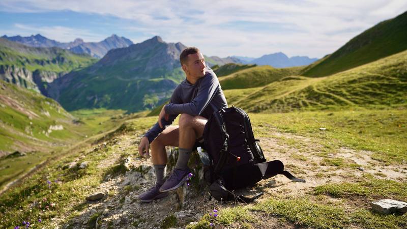
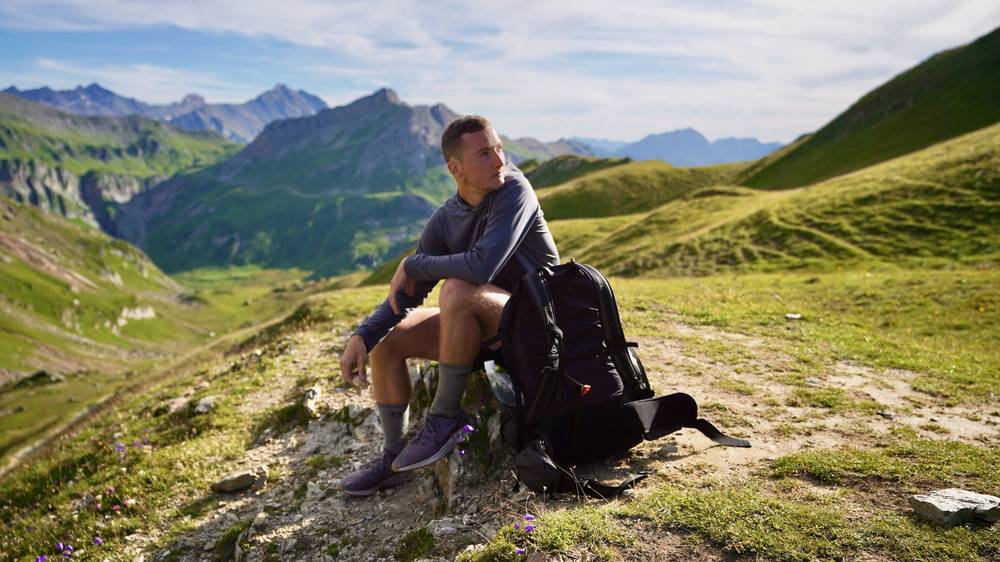
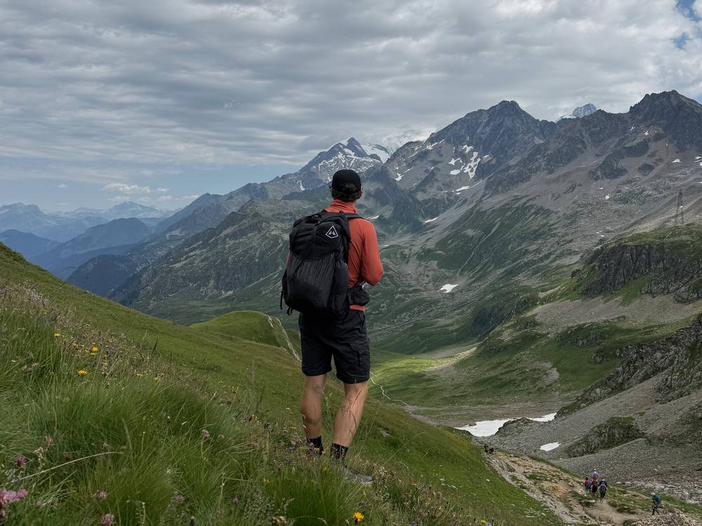
Me at the Col du Bonhomme on Day 2 (2019). 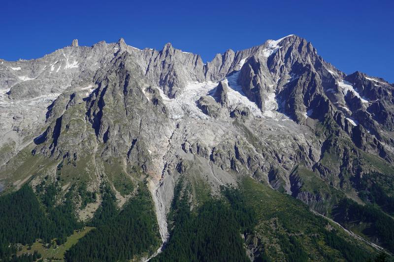
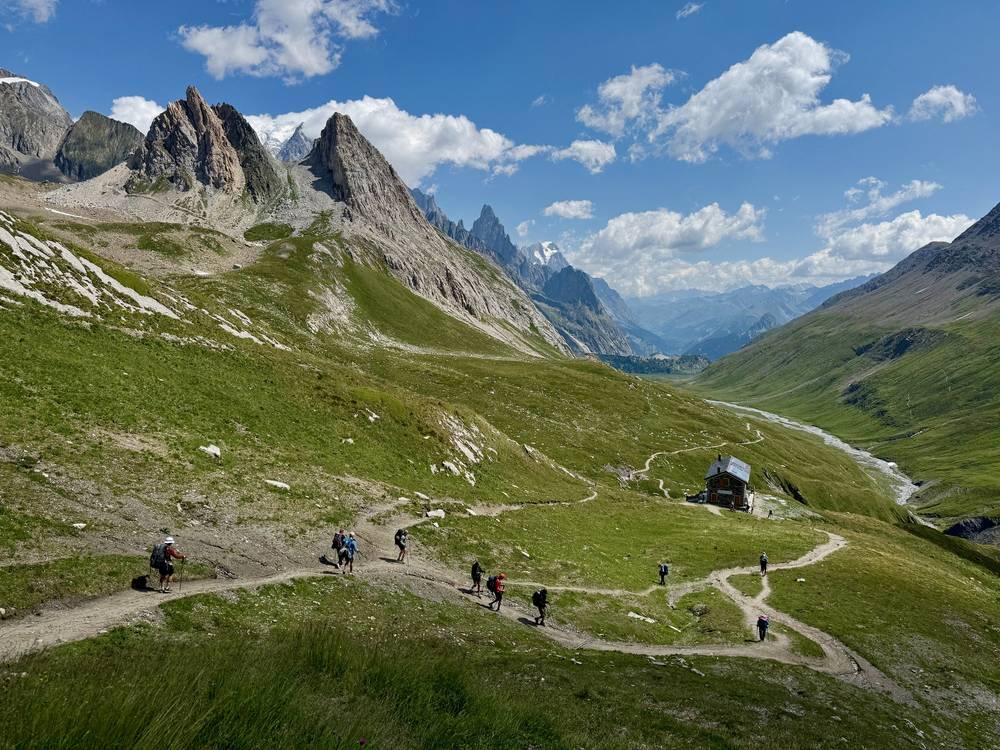
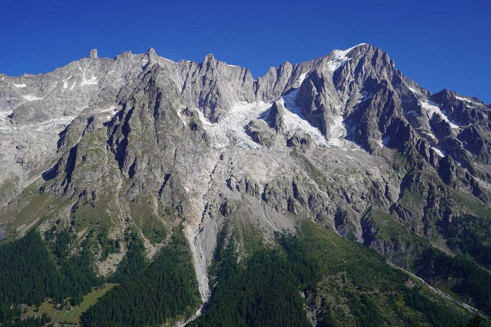
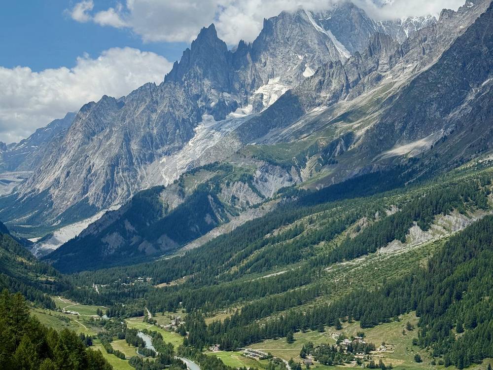
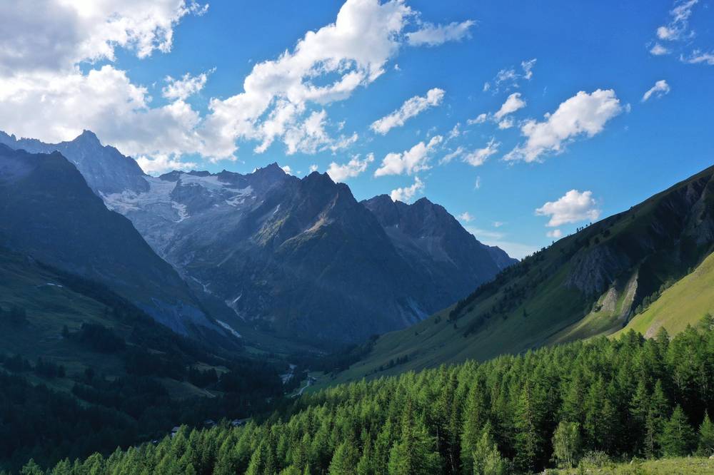
The Grandes Jorasses across Val Ferret from the balcony just past Rifugio Bertone, Day 5 (2019). 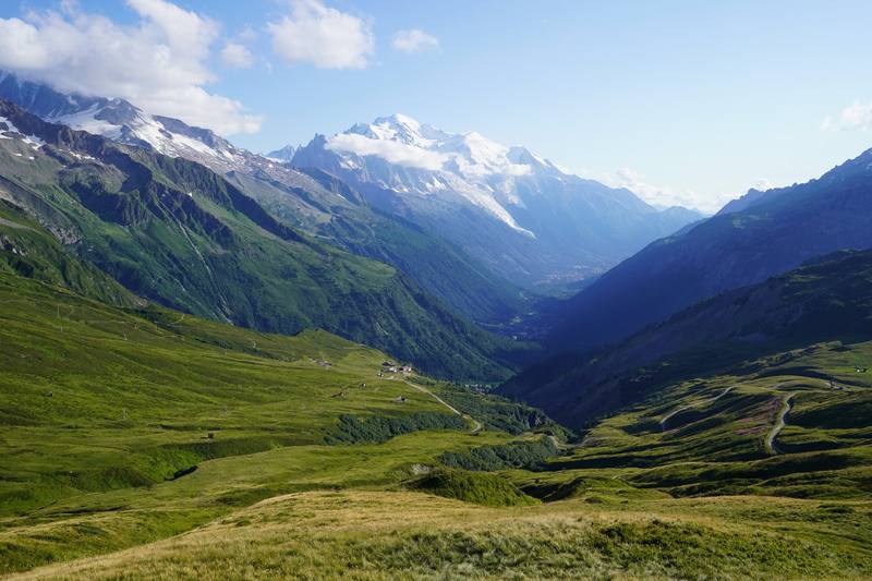
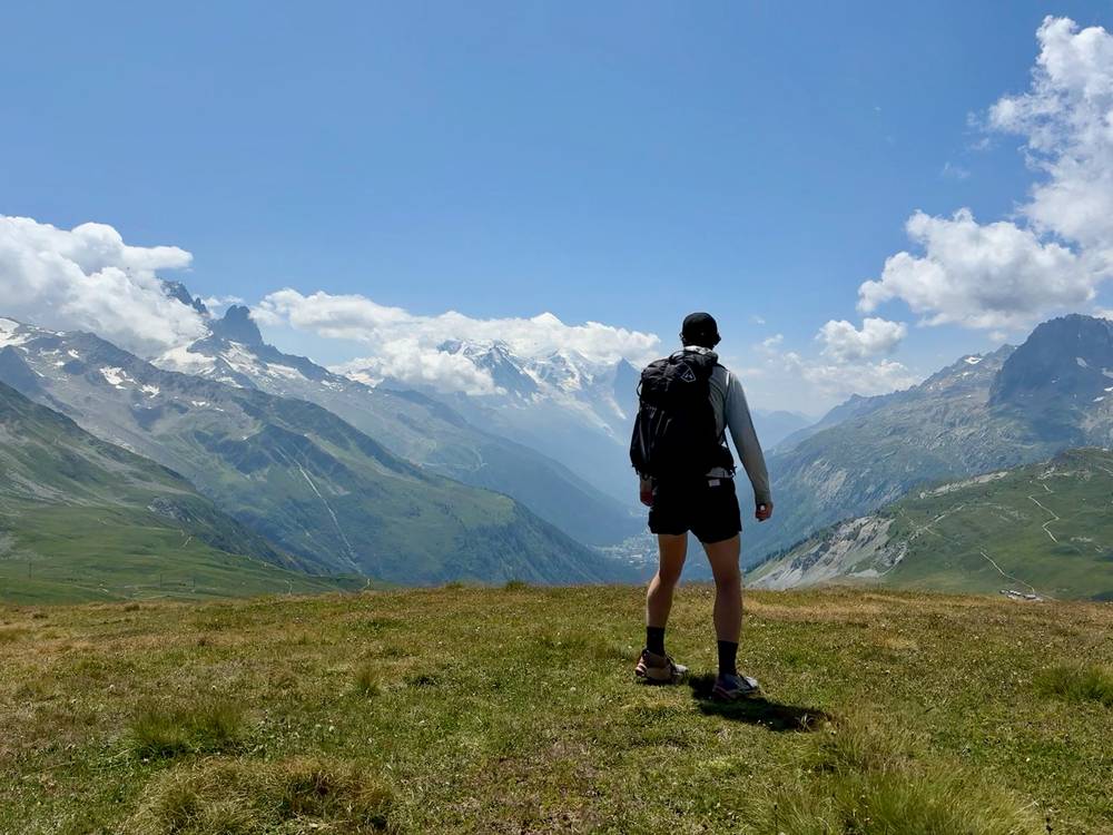
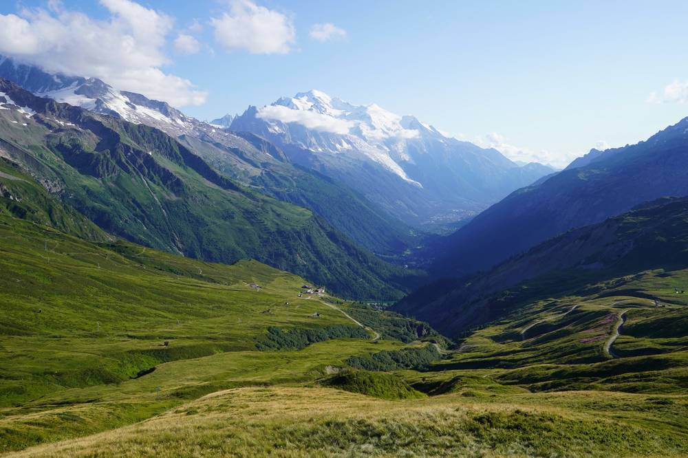
Mont Blanc and the Chamonix valley from the Col de Balme, Day 9 (2019). 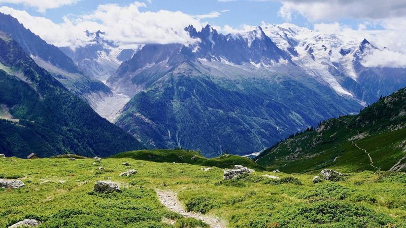
The balcony path from La Flégère toward Planpraz, Day 11 (2019).
Newsletter
Get my letter
Get a short letter from me every couple of weeks: new trips, guides and what I'm building.
Free. Unsubscribe any time.
Details
The guide · Free · 77-page PDF + GPX files · 2027 season edition
Tour du Mont Blanc Hiking Guide
11 days hut to hut around Mont Blanc. Every page is below: read it here, or take it offline as a PDF with my GPX files (77-page PDF + GPX files, in one zip). No sign-up needed.
The route
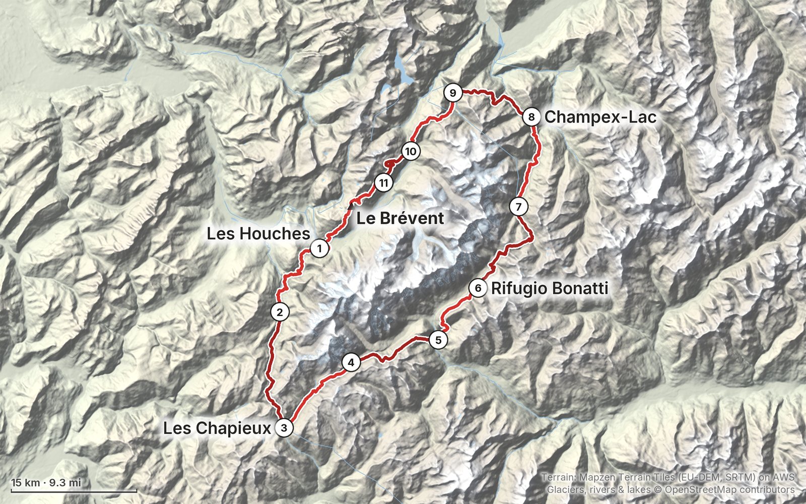
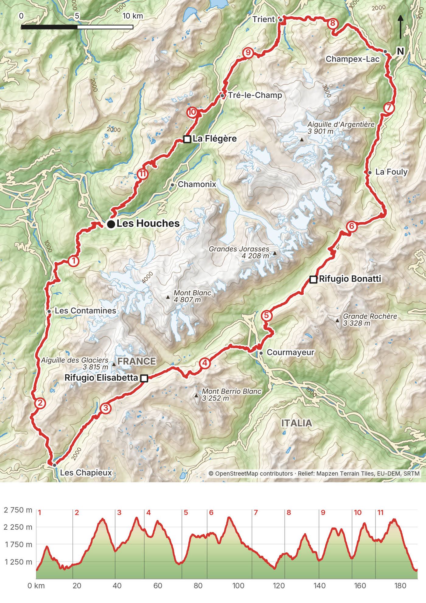
My GPS recording of 11 days on a relief map. The numbers are where each day starts; the red dot is the finish. The day maps are in the guide below, and the GPX files are a free download.
Elevation, start to finish: highest 8,280 ft (2,525 m), lowest 3,190 ft (972 m).
At a glance
- Days
- 11 days
- Distance
- 117 miles
- Climbing
- About 33,800 ft (10,300 m) up
- Season
- Mid-June to mid-September
- Nights
- Refuges, gîtes and small hotels
- Start and end
- Les Houches
Contents
- Welcome
- At a glance
- Straight answers
- My three trips
- When to go
- Booking the refuges
- Getting there
- Buses and lifts
- Day 1 Les Houches to Les Contamines
- Day 2 Les Contamines to Les Chapieux
- Day 3 Les Chapieux to Rifugio Elisabetta
- Day 4 Rifugio Elisabetta to Courmayeur
- Day 5 Courmayeur to Rifugio Bonatti
- Day 6 Rifugio Bonatti to La Fouly
- Day 7 La Fouly to Champex-Lac
- Day 8 Champex-Lac to Trient
- Day 9 Trient to Tré-le-Champ
- Day 10 Tré-le-Champ to La Flégère
- Day 11 La Flégère to Les Houches
- Other ways to do it
- Getting home
- What it costs
- The refuges
- Gear for this route
- Weather and safety
- Using the GPX files
- Before you go, check these
- One-page trip sheet
- About this guide
Welcome
I've walked the Tour du Mont Blanc three times. In August 2019 I hiked it alone, carrying my own gear, from Trient in Switzerland all the way around in five and a half days. In August 2022 I came back and ran it in six days with a group I hosted with Vagabond Trails. In July 2026 I hosted a second group with Vagabond Trails, a six-day hike of the highlights.
None of those trips is the trip most of you will do. Most people walk the TMB hut to hut in 9 to 11 days, carrying a small pack and sleeping in refuges. So this guide is built around that: the classic loop counter-clockwise from Les Houches in 11 days, with each day's line cut from my own GPS recordings, and what happened on that stretch on each of my trips. After my first time I said it was "awesome. I think you should do it yourself." This is everything you need to do that.
What's inside
- Straight answers to the questions people ask me about the TMB
- My three trips, and what the operator arranged on the two group trips
- When to go, how refuge booking works for 2027, and how to get to Les Houches
- The buses and lifts in France, Italy and Switzerland that shorten a day or get you off the trail
- All 11 days: the numbers, what I did there, the trail, where to get off, a map with an elevation profile, and links to that stretch in my films
- The variants I walked, other ways to split the loop, getting home, what it costs, the refuges, the gear for this route (what I carried and filmed with), weather and safety
- One page of things to check before you go, and a printable trip sheet
How to use it offline
Save this PDF to your phone's Files or Books app before you leave home. Load the GPX files and download offline maps while you still have Wi-Fi. Each day starts on a new page, so you can jump straight to it. The film links need a connection; everything else works in airplane mode.
When I say "I," it's my own trip, and I always say which year. Refuge, bus and lift details change, so they're dated, and the checks are collected on one page: Before you go, check these.
At a glance
| Quick facts | |
|---|---|
| Distance | 117.0 miles (188.3 km) over 11 days |
| Climbing | about 33,800 ft (10,300 m) up and the same down |
| Days | 11 walking days; 9 or 10 if you join days |
| Start and finish | Les Houches, 5 miles from Chamonix, France |
| Direction | Counter-clockwise, the usual way |
| Countries | France, Italy, Switzerland |
| Nights | Refuges, gîtes and small hotels; you book each one |
| Highest pass | Grand Col Ferret, 8,323 ft (2,537 m) |
| When | Mid-June to mid-September |
| Difficulty | Long climbs every day; no climbing skills needed |
| Nearest airport | Geneva, about 1.5 hours by road |
| My trips | Aug 2019 solo; Aug 2022 and Jul 2026 with groups |
| Day | Route | Miles (km) | Up / down (ft) |
|---|---|---|---|
| 1 | Les Houches to Les Contamines | 11.2 (18.0) | 3,431 / 2,897 |
| 2 | Les Contamines to Les Chapieux | 13.0 (21.0) | 4,377 / 3,089 |
| 3 | Les Chapieux to Rifugio Elisabetta | 9.0 (14.4) | 3,348 / 1,306 |
| 4 | Rifugio Elisabetta to Courmayeur | 11.6 (18.6) | 1,765 / 4,922 |
| 5 | Courmayeur to Rifugio Bonatti | 7.8 (12.5) | 3,430 / 752 |
| 6 | Rifugio Bonatti to La Fouly | 13.7 (22.0) | 3,119 / 4,521 |
| 7 | La Fouly to Champex-Lac | 10.0 (16.2) | 1,820 / 2,262 |
| 8 | Champex-Lac to Trient | 10.5 (16.9) | 2,658 / 3,252 |
| 9 | Trient to Tré-le-Champ | 10.2 (16.3) | 3,645 / 3,481 |
| 10 | Tré-le-Champ to La Flégère | 7.1 (11.5) | 3,445 / 1,761 |
| 11 | La Flégère to Les Houches | 12.9 (20.8) | 2,748 / 5,508 |
The numbers come from my own GPS recordings, smoothed the same way for every day. The official figure for the TMB is about 105 miles (170 km) and 10,000 m of climbing; my line is longer because it walks into the centre of each town, goes over the top of the Brévent on Day 11, and GPS adds a little on every switchback. Both of my films say 120 miles in the title. My GPS for the whole 2019 loop says 112.4.
Straight answers
How many days do I need? The official site says 7 to 12, and "usually 10 to 11 stages." This guide splits it into 11 days of 7 to 14 miles. In 2019 I did the entire loop in five and a half days, averaging 20 to 25 miles a day, but I was alone and going fast. If you have 10 days, join Days 10 and 11; for 9, also see Other ways to do it.
Which direction? Counter-clockwise. The official site says it's "the most common and the best marked." All three of my trips went that way. Clockwise means fewer people on the trail with you, but more people coming at you.
Where do I start? Les Houches is the classic start, and it's easy from Geneva and Chamonix. It's a loop, so you can start anywhere. In 2019 I started and ended in Trient, in Switzerland, because I came by train to Martigny.
When should I go? Mid-June to mid-September, when the passes are clear and the refuges are open. In 2019 I went in mid-August (August 14 to 19): "the temperature was fantastic. There was barely any snow." I also said that "when I went was probably the busiest time." See When to go.
Do I need to book the refuges? Yes. In 2019 I said the refuges "were definitely booked multiple days in advance. So if you go when I went you definitely want to book your refuges early." Bookings for summer 2027 open on the official platform on October 15, 2026. See Booking the refuges.
Can I camp? Only in a few places. Italy bans camping, and bivouac below 2,500 m, which is almost the whole Italian section. Switzerland mostly bans it outside campsites. France allows a one-night bivouac in some communes and has booked bivouac areas in others. In 2019 I said "the rules are different in each country... you definitely have to look that up." The summary is in The refuges.
Am I fit enough? In 2019 I said it's "for everyone," because it's "very developed and very accessible." That's true of the trail and the services. It's still a real hike: most days climb 3,000 to 4,400 ft. Test yourself at home: walk 10 to 12 miles with 3,000 ft of climbing and your pack, two days in a row. If the second day feels fine, you're ready.
Is it crowded? Yes, in July and August. In 2019 I said it was "a bit more crowded than what I'm used to," but "I highly enjoyed it. Got to talk to a couple different people." The Italian side had "the least amount of people."
What will it cost? The official FAQ says half board in a dorm costs about €65 to €95 a night. Most 2026 prices in this guide fall in that range, plus lunch, drinks, buses and lifts. See What it costs.
Cash or cards? Bring both, in euros and Swiss francs. In 2019 I found "50/50 that I visited were cash only." That's still true: Nant Borrant, La Balme, the Chapieux refuge La Nova, Mottets, Elisabetta and Lac Blanc take cash only for your balance.
Do I need a map? In 2019 I used my phone: "all trails is the best... GPS works, even if your data is off." Load this guide's GPX files and download offline maps. There's no phone signal from Les Contamines over to Lac Combal in Italy.
Can I do it with a company? Yes. My 2022 and 2026 trips were run by an operator, which booked the beds, moved the bags and handled the transfers. See My three trips.
My three trips
All three went counter-clockwise. Here's what each one was, so you know where my notes come from.
2019, solo (August 14 to 19). I flew from New York to Zurich and Geneva, took the train to Martigny, and walked up to Trient, where I started and ended the loop. I carried my own pack and a camera, didn't cook, and "just bought bread, Twix, sausages and cheese" and had a meal "whenever I hit a big restaurant, cafe or refuge." I listened to four audiobooks. My GPS recorded the whole loop, 112.4 miles in six recordings. One night I stopped high below the Col des Fours; see Day 2. The film is Hiking 120 miles Alone on the Tour Du Mont Blanc, a silent film of the hike followed by a Q&A about the route.
2022, group trail run (August 1 to 6). A group trip I hosted with Vagabond Trails, with my brother along. We ran it in six stages from Chamonix: Les Contamines, Les Mottets, Courmayeur, La Fouly, Trient and back to Chamonix. The operator booked the beds and moved our bags; I said day two was "so much nicer without a pack." I filmed it all on an iPhone: Trail Running 120 miles on the Tour Du Mont Blanc in the Alps.
2026, group hike (July 16 to 21). A second trip I hosted with Vagabond Trails: six days of the highlights, using lifts and transfers to skip the valley stretches. Vagabond Trails arranged the rooms and refuges, the meals, the luggage, the lifts and every transfer, including the long one from La Fouly to Trient. I recorded all six days, but I haven't made a film of this one.
What that means for you. On the group trips I didn't book anything. If you go on your own, every refuge, bus and lift in this guide is yours to arrange. Where a day below uses 2022 or 2026 notes, remember someone else had booked the beds.
When to go
The season. The official site says mid-June to mid-September, "when the mountain passes are free of snow and the refuges are open." Most refuges open in early to mid-June and close in mid to late September. Some close earlier: in 2026 the Cabane du Combal closed on September 15 and La Peule on September 18.
June. In 2019 I said: "If you go in early June you're gonna see a lot of snow in the passes probably." The official site says snow lingers on the north sides of the Bonhomme, the Col des Fours and the Fenêtre d'Arpette before mid-June, and some waymarks may still be missing.
July and August. Busy and warm. My trips were July 16 to 21, August 1 to 6 and August 14 to 19. Storms usually come in the afternoon, between 2 and 5 p.m., so start early. La Chamoniarde, Chamonix's mountain safety office, says July 14 to August 15 is the busiest, and a midweek start helps because guided groups start on weekends.
Late August to mid-September. Calmer, except the UTMB race week at the end of August (2027 dates weren't out in September 2026). Days get shorter and a few refuges close before the end of the month.
What I got. Clear, warm days on all three trips. In 2019 there was fog in the woods on the last afternoon above Trient. In 2019 I also noticed "there was like a big ultra marathon that was getting ready the week after I was there so there were people training."
Booking the refuges
How it works
Most refuges and gîtes on the TMB are booked on the official platform, montourdumontblanc.com, run by the association of TMB refuge wardens.
- Bookings for summer 2027 open October 15, 2026, for all refuges on the platform.
- You choose each night, pay a deposit online, and pay the balance at the refuge. The deposit is set by each refuge.
- Cancelling (terms updated August 2026): more than 30 days before arrival, 80% of what you paid comes back; 30 days or less, nothing. You can change dates online up to 30 days before.
- The standard booking is half board: bed, dinner and breakfast. Picnic lunches are ordered the evening before.
- A sleeping-bag liner is required in almost every refuge. Blankets or duvets are provided.
Not on the platform (book on their own sites, by email or phone): Rifugio Elisabetta, Cabane du Combal, Rifugio Bonatti, Rifugio Elena, Refuge du Lac Blanc, Refuge de la Flégère, Refuge de Bellachat, Refuge du Col de Balme and Refuge de Miage. Some open bookings on their own dates: Col de Balme opened 2026 bookings on April 1, 2026, and La Flégère takes 2027 requests from January 5, 2027.
What to book first
The official advice is to book the smallest refuges first, then build the rest around them. On this plan that means Elisabetta (Day 3), Bonatti (Day 5), Lac Blanc or La Flégère (Day 10), and anything at Les Chapieux (Day 2). Towns (Les Contamines, Courmayeur, La Fouly, Champex, Trient, Les Houches) have more beds and hotels.
The Croix du Bonhomme refuge is closed. The refuge at the Col de la Croix du Bonhomme (Day 2) shut on August 17, 2026 for rebuilding and won't reopen until 2029. No beds, meals or shelter there in 2027 and 2028. That's why Day 2 goes all the way to Les Chapieux. I couldn't find an official notice about the path past the building site; check before you go.
In 2019, 2022 and 2026
In 2019 I booked as I went, and I said the refuges were full days ahead in early August, so book early. I said to expect "maybe 50 to 100 dollars for the refuges" and "anywhere from 100 to 300 dollars" for hotels in the towns (my 2019 estimates). In 2022 and 2026 Vagabond Trails booked every night. If you'd rather not book it yourself, companies sell self-guided and guided TMB trips with the beds already arranged.
Getting there
What I did. In 2019 I "flew from New York to Zurich, Zurich to Geneva and then from Geneva I took a train over to Martigny," then walked up to Trient. In 2022 I took a shared bus from Geneva Airport to Chamonix. In 2026 the operator's shared transfer took us from Geneva Airport to Chamonix Sud.
Geneva to Les Houches by train. Take a train from the airport to Geneva's main station, then the Léman Express L3 to Saint-Gervais-Le Fayet and the Mont-Blanc Express up the valley to Les Houches. Chamonix's tourist office gives about 2 hours 40 minutes from Geneva to Chamonix. Summer 2026 Mont-Blanc Express trains left Saint-Gervais about hourly.
By bus or shuttle. FlixBus listed at least four buses a day from Geneva Airport to Chamonix in 2026, from about 1 hour 25 minutes. Shared shuttles take about 1 hour 15 minutes; the Chamonix tourist office gave €30 to €40 a person, and private transfers from about €150. Then take bus line 1 or the train to Les Houches.
Stay a night. Most people sleep in Chamonix or Les Houches before Day 1. Hotels there give you a guest card (carte d'hôte). Since 2026 it no longer makes the buses free: it gives cheaper bus passes, and free train rides between Servoz and Vallorcine.
From Italy or Switzerland. You can start anywhere on the loop: Courmayeur (Day 5) is linked to Chamonix by bus through the Mont Blanc Tunnel, and Champex-Lac (Day 8) and Trient (Day 9) are reached from Martigny.
Buses and lifts
Every day of the TMB has a bus or a lift somewhere near it, which is why it's easy to shorten a day or skip one. These are the ones on this route, with summer 2026 dates.
| Where | What | Summer 2026 | Day |
|---|---|---|---|
| Les Houches | Bellevue cable car up to Col de Voza | Jun 6 to Sep 13; €18.90 one way | 1 |
| Saint-Gervais | Tramway du Mont-Blanc to Col de Voza | Jun 13 to Sep 27; €22.70 one way from Le Fayet | 1 |
| Les Contamines | Free shuttle to Notre-Dame de la Gorge | Jun 27 to Aug 30 | 2 |
| Les Chapieux | Shuttle to La Ville des Glaciers; bus to Bourg-Saint-Maurice | Jun 13 to Sep 13; €5 return; €8 one way | 2, 3 |
| Courmayeur | Free Arriva buses to La Visaille (Val Veny) and Lavachey and Arnouvaz (Val Ferret) | Jun 11 to Sep 27 | 4, 5, 6 |
| Courmayeur | Dolonne gondola to Plan Chécrouit | Jun 27 to Aug 30 | 4 |
| Courmayeur | Bus to Chamonix through the Mont Blanc Tunnel | Reservation required; €15 one way | 4, 5 |
| La Fouly | TMR bus 12.272 to Orsières | All year | 6, 7 |
| Champex-Lac | TMR bus 12.271 to Orsières; La Breya chairlift | Bus all year; chairlift Jun 13 to Sep 21 | 7, 8 |
| Col de la Forclaz | TMR bus 12.230 via Trient to Le Châtelard | Daily Jun 29 to Aug 23, weekends in June and September | 8, 9 |
| Le Tour | Charamillon gondola and Autannes chairlift to the Col de Balme area | Jun 20 to Sep 20 | 9 |
| Tré-le-Champ | Train at Montroc; bus 2 from Le Tour to Chamonix | Train all year; bus every 30 minutes | 9, 10 |
| La Flégère | Cable car down to Les Praz | Jun 20 to Sep 13 | 10, 11 |
| Planpraz | Gondola down to Chamonix | Jun 13 to Sep 13 | 11 |
| Les Houches | Bus 1 and the train to Chamonix | All year | 11 |
Tickets. French buses take a card on board (Chamonix valley single €1.70 online or €2.20 by card on board, from July 1, 2026). The Courmayeur buses were free in summer 2026, paid by the town. The Bellevue and Tramway fares had no year printed on them in September 2026.
Closed in 2026. The Plan Chécrouit gondola and the Maison Vieille chairlift above Courmayeur were closed for rebuilding; only the Dolonne gondola ran. The Mont Blanc Tunnel is expected to close again for about 15 weeks in autumn 2027 for repairs (in 2025 it was shut September 1 to December 12), and no bus runs through it then: check tunnelmb.net.
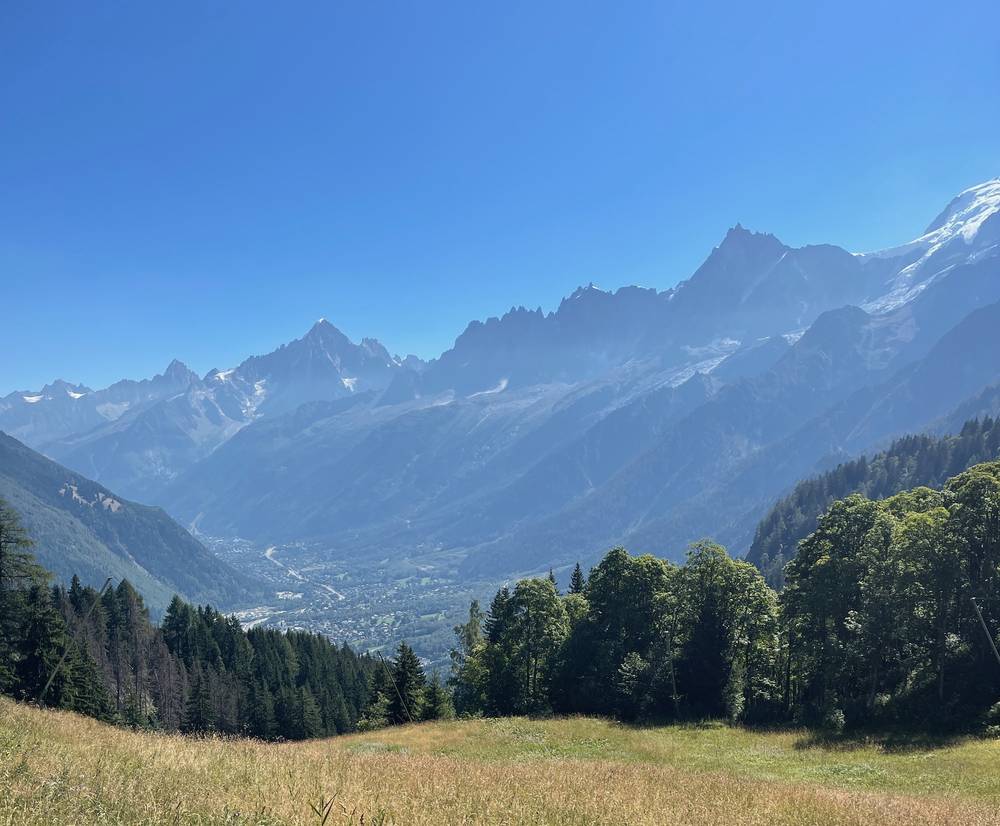
Day 1: Les Houches to Les Contamines
- Distance
- 11.2 mi (18.0 km)
- Climbing
- 3,431 ft (1,046 m)
- Descent
- 2,897 ft (883 m)
- Time to allow
- 6.5 to 7.5 hours
- High point
- Col de Voza, 5,423 ft (1,653 m)
- Sleep
- Les Contamines-Montjoie: Gîte Le Pontet (€54.20 half board, 2026) or hotels; or go on 1.5 hours to Nant Borrant or about 2.5 hours to La Balme
- Food and water
- Shops and cafés in Les Houches and Les Contamines. Carry lunch and water.
- Buses and lifts
- Bellevue cable car or the Tramway du Mont-Blanc cut out the first climb
What I did here
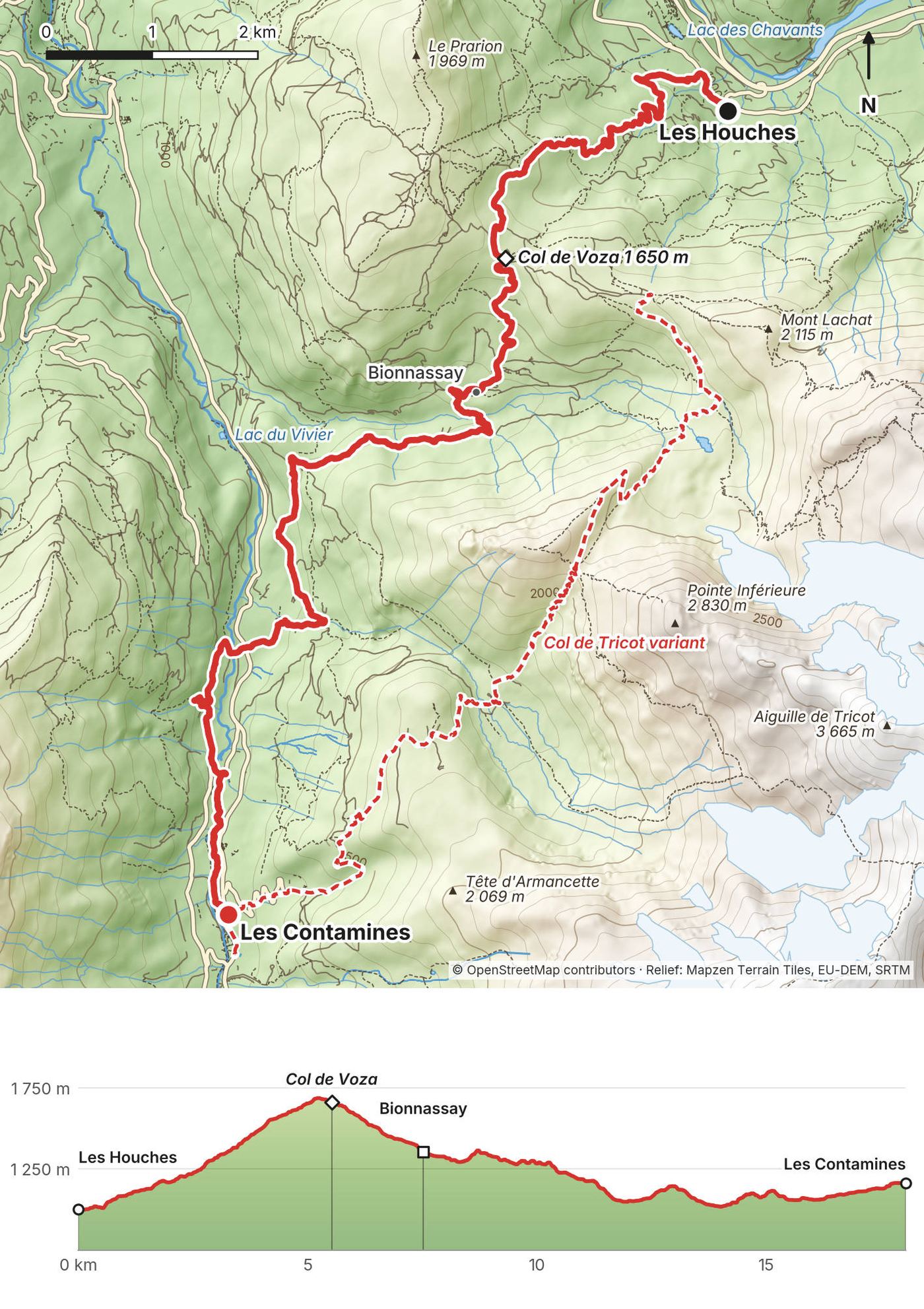
In 2019 I walked this on August 16, starting in Les Houches at 9:38 a.m. I was at the Col de Voza at 10:55 and in Les Contamines by 2:20 p.m., and I kept going that same day, over the Col du Bonhomme. That's the line in your GPX file.
In 2022 we ran from Chamonix, up through Les Houches and over the Col de Tricot instead: "We have 16, 17 miles to trail run to a hut." At the high point, "this is the peak summit for today. The highest pass. We're going to have some sandwiches that we've been carrying all day." At the end: "That was 17.7 miles as far as I tracked... I feel really great, actually. Time for a hotel now."
In 2026 the group took the Bellevue cable car and walked the Col de Tricot variant to Les Contamines, from 10:01 a.m. to 4:40 p.m.
The trail
From Les Houches the route climbs forest tracks and ski slopes to the Col de Voza, 1,653 m, at 3.4 miles, the only climb of the main route today. The Tramway du Mont-Blanc crosses here. It then drops through the hamlet of Bionnassay (4.7 miles), crosses the stream below the Bionnassay glacier, and follows quiet roads and paths down through Le Champel (6.7 miles) and the villages along the valley to Les Contamines. The last few miles are gentle and low.
The Col de Tricot variant (my 2022 and 2026 line, in the GPX as a separate file) goes from Bellevue across the Bionnassay glacier stream on a suspension bridge, climbs steeply to the Col de Tricot at 2,120 m, and drops to the Chalets de Miage and the Auberge du Truc before descending to Les Contamines. From Bellevue it's 8.2 miles with 2,160 ft of climbing and 4,259 ft of descent. It's harder and more scenic; do it in good weather.
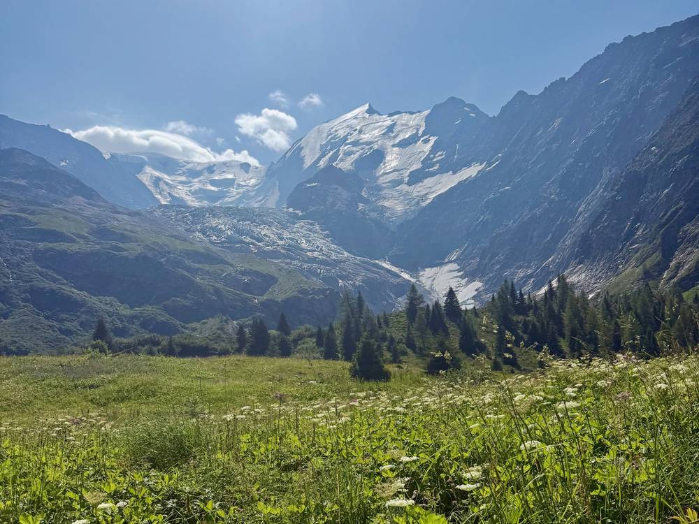
If you need to get off
The Tramway du Mont-Blanc stops at Col de Voza and Bellevue and goes down to Saint-Gervais. From Les Contamines, buses run to Saint-Gervais-Le Fayet for the train.
Watch this day
2019 film, the day through Les Contamines · 2022 film, Day 1
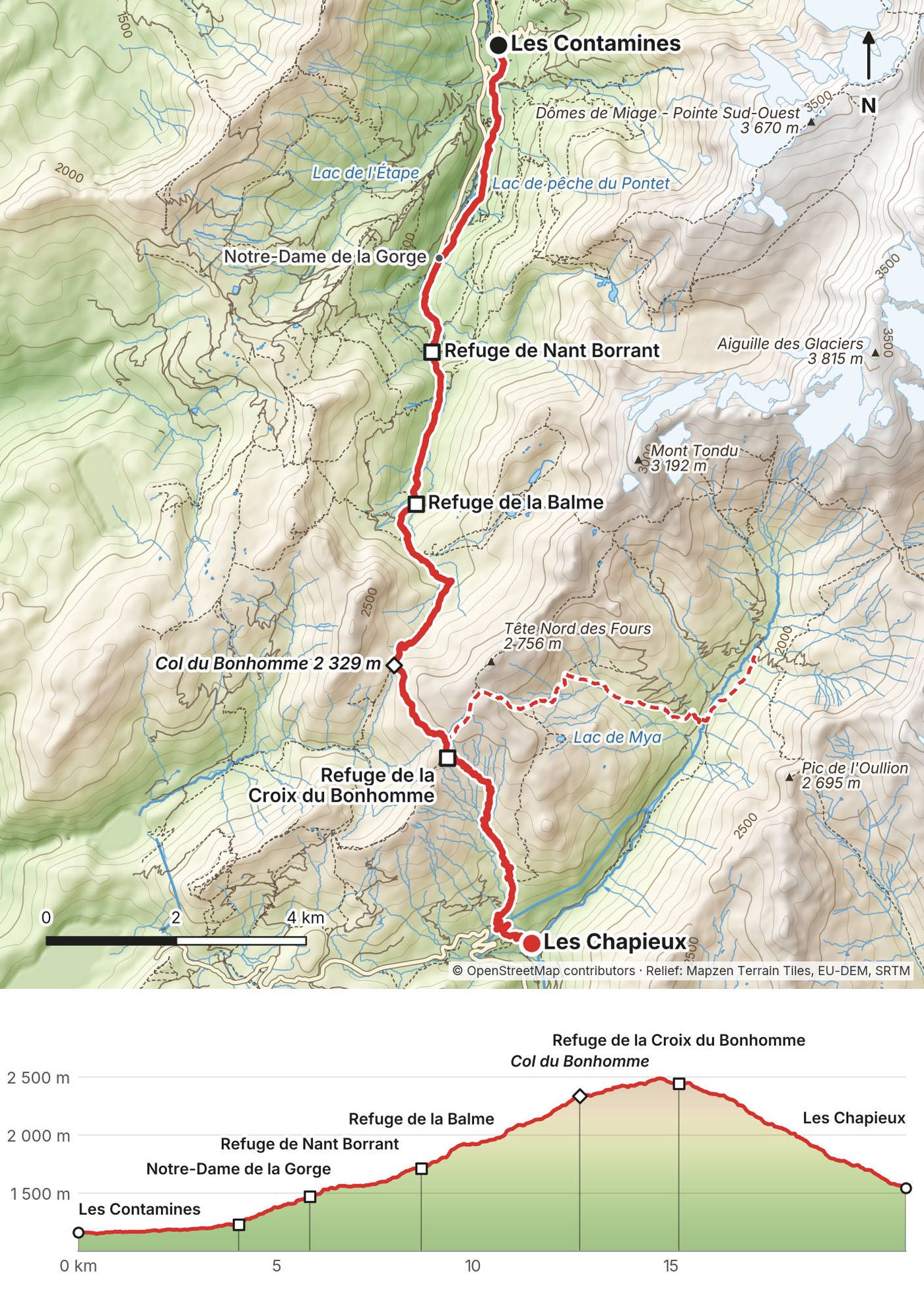
Day 2: Les Contamines to Les Chapieux
- Distance
- 13.0 mi (21.0 km)
- Climbing
- 4,377 ft (1,334 m)
- Descent
- 3,089 ft (941 m)
- Time to allow
- 8.5 to 9.5 hours
- High point
- Col de la Croix du Bonhomme, 8,133 ft (2,479 m)
- Sleep
- Les Chapieux: Auberge-Refuge de la Nova or Les Chambres du Soleil. The Croix du Bonhomme refuge is closed until 2029.
- Food and water
- Nant Borrant and La Balme refuges (1.5 to 2.5 hours in); then nothing until Les Chapieux
- Buses and lifts
- Free shuttle Les Contamines to Notre-Dame de la Gorge (summer); bus from Les Chapieux to Bourg-Saint-Maurice
What I did here
In 2019 I left Les Contamines at 2:20 p.m. on August 16, passed Notre-Dame de la Gorge at 3:07, reached the Col du Bonhomme at 5:57 and took the Col des Fours variant, at 2,665 m the highest point of the whole TMB, at 7:27 p.m. My recording stops at 9:02 p.m. below the col at about 2,265 m and starts again from the same spot at 7:54 the next morning. That's where I stopped for the night. Don't copy it: bivouac isn't allowed in the Vallée des Glaciers outside the camping at La Ville des Glaciers.
In 2022: "So, it's day two. We're going up close to Italy today. But, man, it is so much nicer without a pack and not filming." We also went over the Col des Fours, to the Refuge des Mottets.
In 2026 we started from Notre-Dame de la Gorge at 8:32 a.m., were at the Col du Bonhomme at 11:49 and the Croix du Bonhomme refuge at 1:50 p.m., and got to Les Chapieux at 3:19. Your GPX follows my 2019 line to the Col du Bonhomme and my 2026 line from there.
The trail
A long, steady climb, then a long descent. From Les Contamines the path follows the river to the chapel of Notre-Dame de la Gorge (2.5 miles), where the road ends. Then it climbs an old Roman road to Nant Borrant (3.6 miles), up the open valley past La Balme (5.4 miles), and on to the Plan Jovet area and the Col du Bonhomme, 2,329 m, at 7.9 miles. The last pitch to the col crosses rocky ground that can hold snow into July.
From the Col du Bonhomme a traverse leads to the Col de la Croix du Bonhomme, 2,479 m, and the refuge (closed; 9.5 miles). From there the main route drops about 2,900 ft to Les Chapieux, a hamlet with two auberges, a small shop and the official bivouac area.
The Col des Fours variant (my 2019 and 2022 line) climbs from the refuge to the Col des Fours, 2,665 m, and drops straight to La Ville des Glaciers and the Refuge des Mottets, skipping Les Chapieux. From the refuge to Mottets it's 5.2 miles with 1,036 ft up and 2,917 ft down. Only in clear weather with no snow.
No signal. The official site says there's no mobile signal from Pont Romain above Les Contamines to the Col de la Seigne and down to Lac Combal.
If you need to get off
Before the pass, go back to Notre-Dame de la Gorge. After the Croix du Bonhomme, keep going to Les Chapieux: the summer bus goes down to Bourg-Saint-Maurice and its train station.
Watch this day
2019 film, the Bonhomme and the Col des Fours · 2022 film, Day 2
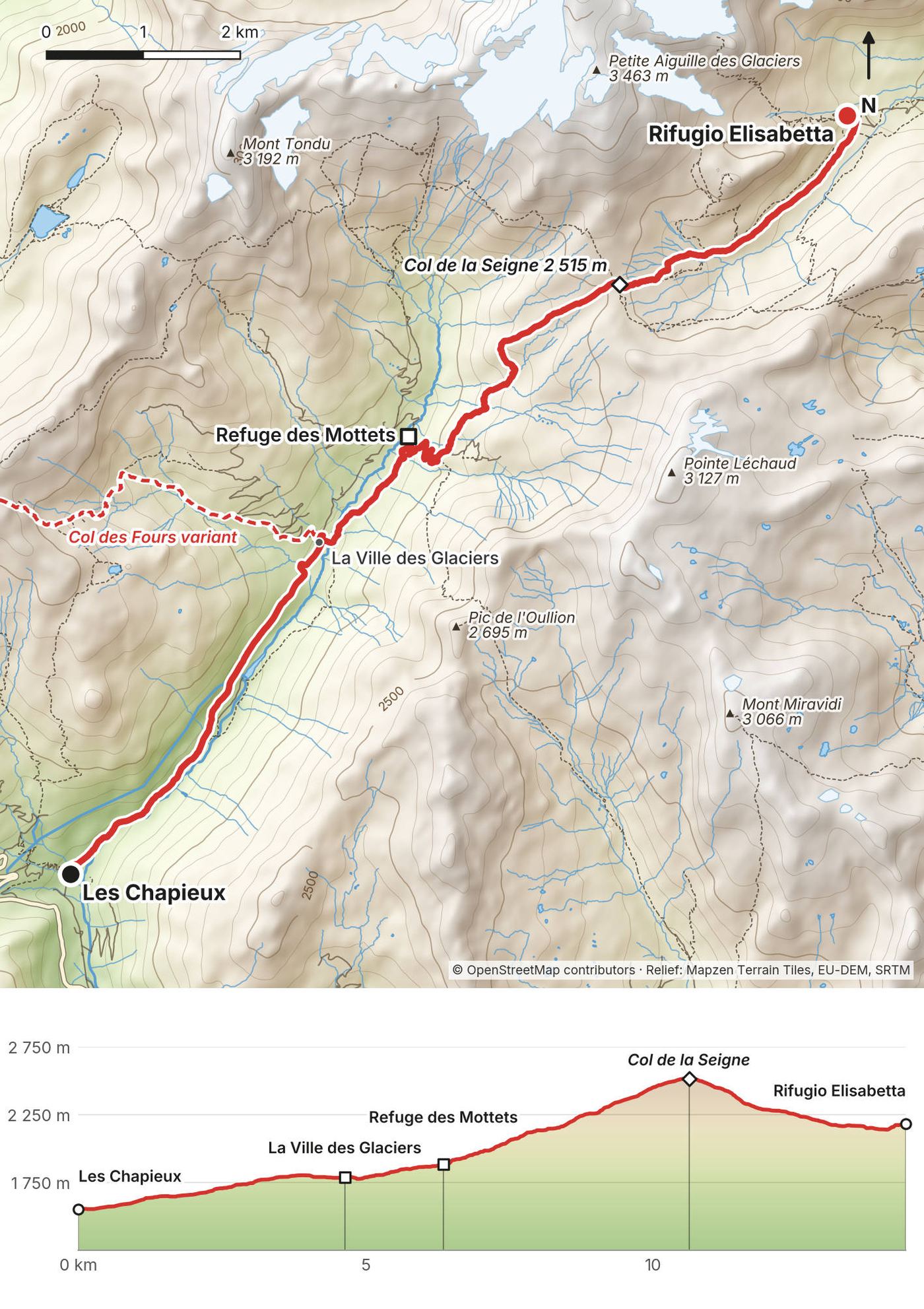
Day 3: Les Chapieux to Rifugio Elisabetta
- Distance
- 9.0 mi (14.4 km)
- Climbing
- 3,348 ft (1,021 m)
- Descent
- 1,306 ft (398 m)
- Time to allow
- 5.5 to 6.5 hours
- High point
- Col de la Seigne, 8,255 ft (2,516 m), the border with Italy
- Sleep
- Rifugio Elisabetta (book direct); or Refuge des Mottets, 4 miles in
- Food and water
- Refuge des Mottets (4 miles); Rifugio Elisabetta at the end
- Buses and lifts
- Summer shuttle Les Chapieux to La Ville des Glaciers skips the first 2.9 miles of road
What I did here
In 2019 I came down from the Col des Fours on August 17 and reached La Ville des Glaciers at 9:01 a.m. I was at the Col de la Seigne at 10:42 and Rifugio Elisabetta at 11:36, and went on to Courmayeur the same day.
In 2022 we left the Refuge des Mottets just before 8 a.m. "Good morning. It is day three. We're going to be running up that hill. Italy is next." At the col: "I'm in France, and now I'm in Italy." And after: "I'm in Italy. Can see Mont Blanc there."
In 2026 the group rode the shuttle to La Ville des Glaciers, started walking at 8:51 a.m., and reached the Col de la Seigne at 10:12 and Elisabetta at 12:13.
The road. None of my trips walked the 2.9 miles from Les Chapieux up to La Ville des Glaciers. That part of the GPX is traced along the road from OpenStreetMap, not my recording.
The trail
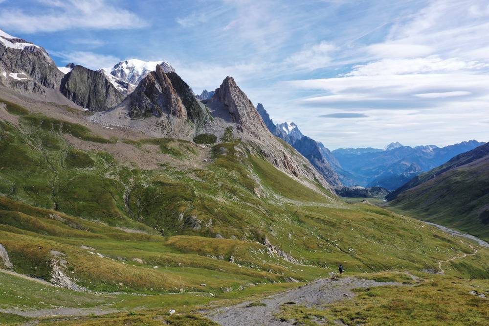
The first 2.9 miles follow the road up the Vallée des Glaciers to La Ville des Glaciers, about 1,790 m. The road is closed to cars from 7:30 a.m. to 6 p.m. in summer, and the shuttle runs it. A track then crosses to the Refuge des Mottets (4.0 miles), and the path climbs in long switchbacks to the Col de la Seigne, 2,516 m, at 6.6 miles. On a clear day you see the south side of Mont Blanc from here.
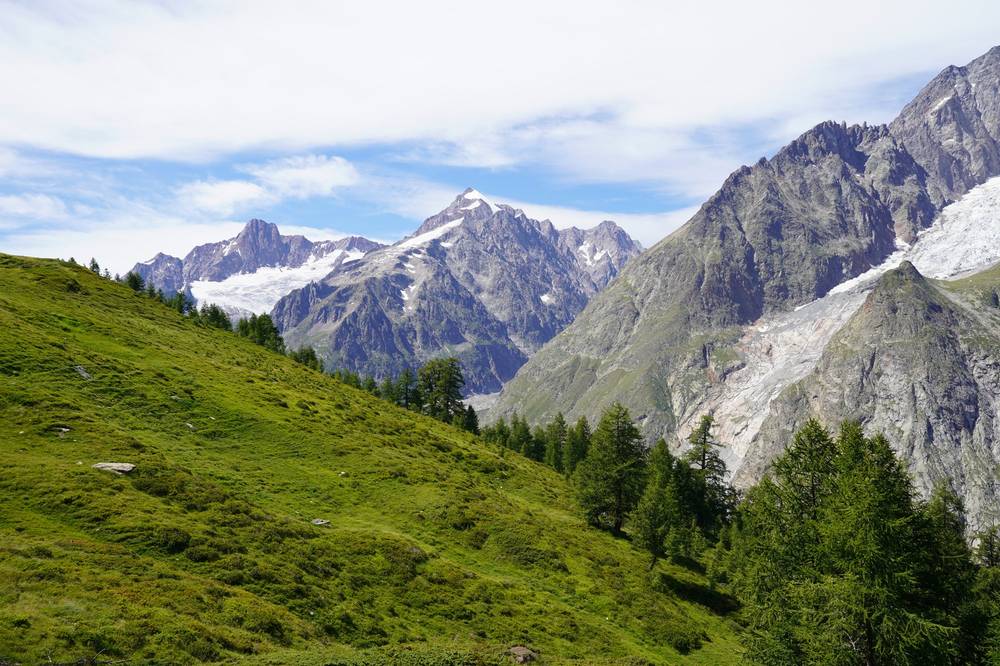
From the col it's a gentle descent past La Casermetta, a small visitor centre open in summer (in 2026 it closed on September 11), to Rifugio Elisabetta, perched on a shelf above the Lée Blanche plain at 2,195 m.
If you need to get off
Back to La Ville des Glaciers for the shuttle. After the col, carry on down Val Veny past Lac Combal to La Visaille, 4.5 miles below Elisabetta, for the free bus to Courmayeur.
Watch this day
2019 film, the Col de la Seigne · 2022 film, Day 3
Day 4: Rifugio Elisabetta to Courmayeur
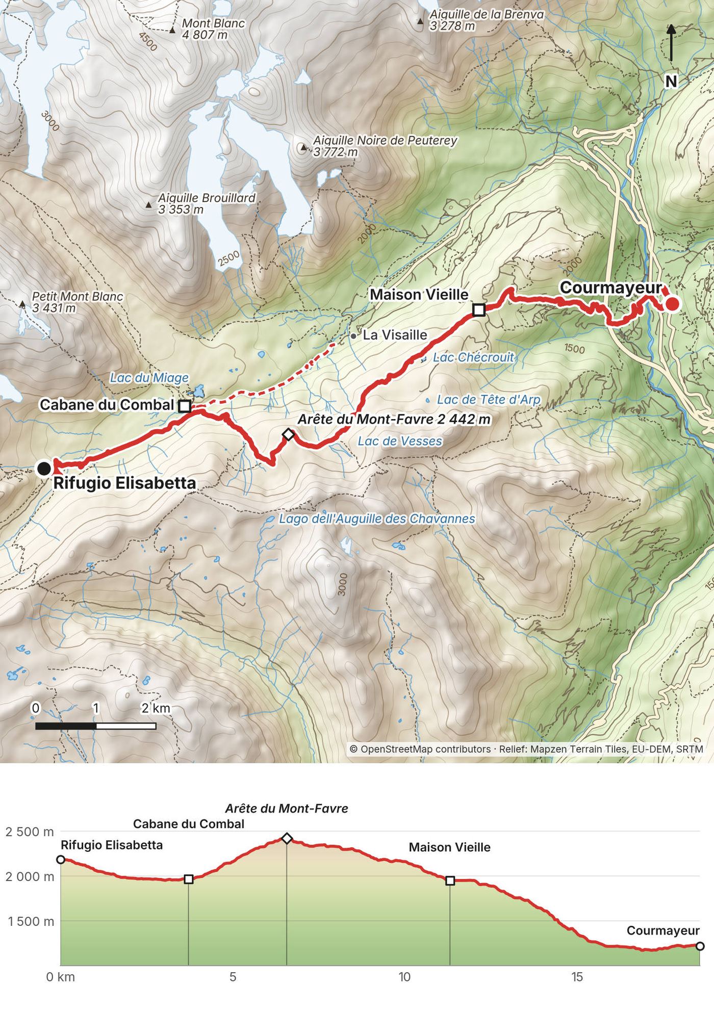
- Distance
- 11.6 mi (18.6 km)
- Climbing
- 1,765 ft (538 m)
- Descent
- 4,922 ft (1,500 m)
- Time to allow
- 6.5 to 7.5 hours
- High point
- Arête du Mont-Favre, 8,012 ft (2,442 m)
- Sleep
- Courmayeur: hotels of every kind; or Rifugio Maison Vieille at the Col Chécrouit (TMB platform)
- Food and water
- Cabane du Combal (2.3 miles); Maison Vieille and other huts at the Col Chécrouit (7.4 miles); everything in Courmayeur
- Buses and lifts
- Free Val Veny bus from La Visaille (low route); Dolonne gondola from Plan Chécrouit down to Courmayeur (summer)
What I did here
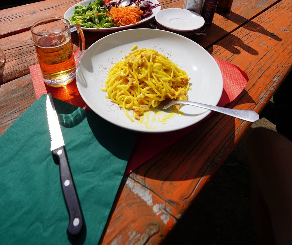
In 2019 this was my favorite part. I left Elisabetta at 11:36 a.m. on August 17, was on the Arête du Mont-Favre at 1:43 p.m. and at Maison Vieille at 3:31. I had lunch on a refuge terrace at the Col Chécrouit and walked down to Courmayeur. I said later: "Especially Italy, the Italian section was my favorite because there was the least amount of people, the best food."
In 2022 we ran it the same way, past the Col Chécrouit at 1:32 p.m. and into Courmayeur at 3:12. That evening: "Look at the size of these pizzas."
In 2026 the group took the low route down Val Veny to La Visaille and the bus to Courmayeur.
The trail
From Elisabetta the track drops to the Lée Blanche plain and follows it to Lac Combal and the Cabane du Combal (2.3 miles). The TMB then climbs out of the valley onto the Arête du Mont-Favre, a balcony at about 2,430 m facing the Miage glacier and the south face of Mont Blanc, reached at 4.1 miles. It traverses to the Col Chécrouit, 1,952 m, at 7.4 miles, where there are several huts and ski lifts, then drops steeply through the woods to Dolonne and across the river into Courmayeur.
The low route (my 2026 line, in the GPX): from Elisabetta straight down the valley road past Lac Combal to La Visaille, 4.5 miles with 1,597 ft of descent, then the free bus to Courmayeur. Use it in bad weather.
The descent from the Col Chécrouit to Dolonne is steep, about 2,500 ft. In summer 2026 you could ride the Dolonne gondola down from Plan Chécrouit instead.
If you need to get off
At Lac Combal, take the valley road down to La Visaille for the bus. From the Col Chécrouit, the Dolonne gondola goes down to Courmayeur.
Watch this day
2019 film, Italy · 2022 film, into Courmayeur
Day 5: Courmayeur to Rifugio Bonatti
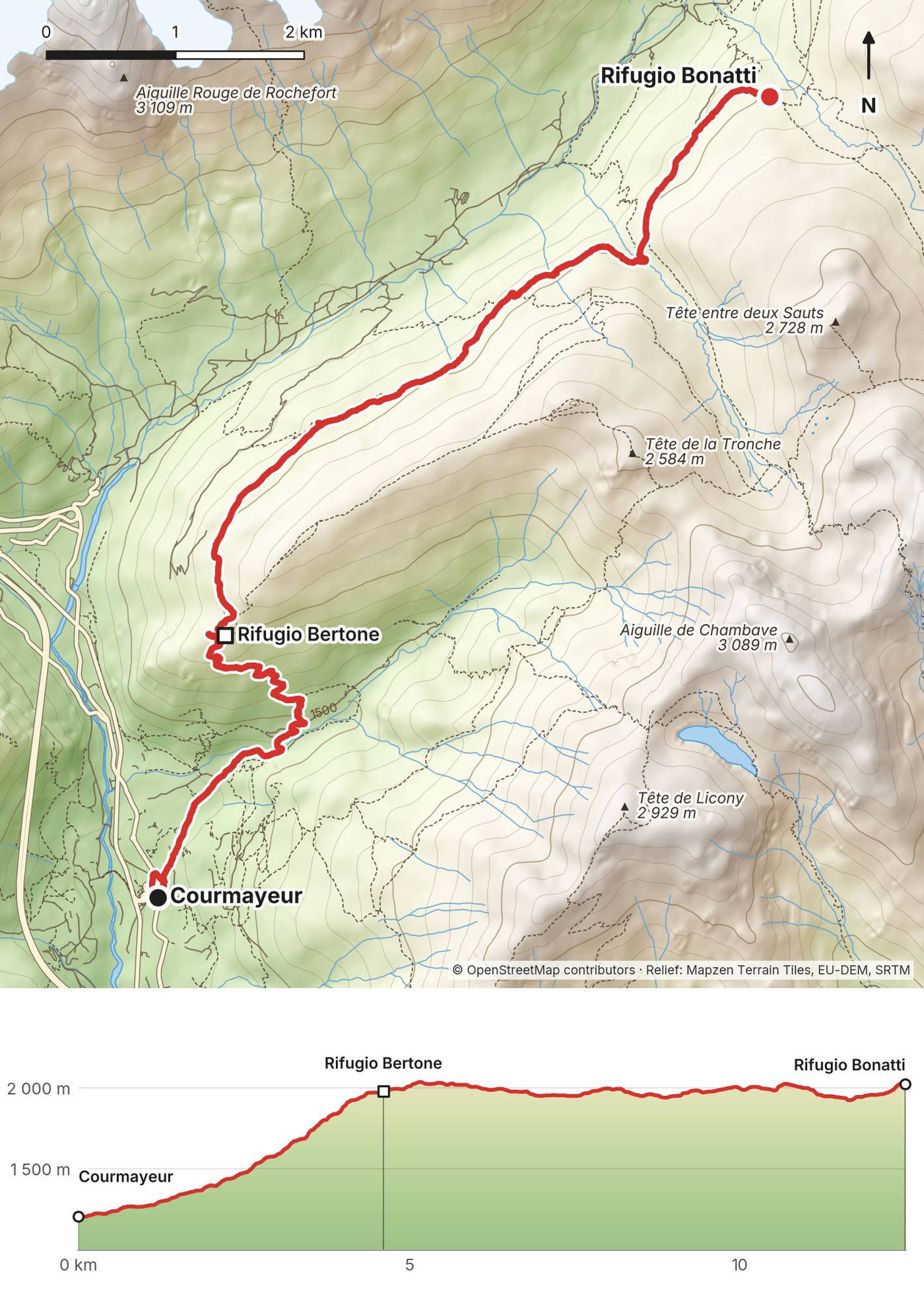
- Distance
- 7.8 mi (12.5 km)
- Climbing
- 3,430 ft (1,046 m)
- Descent
- 752 ft (229 m)
- Time to allow
- 5 to 6 hours
- High point
- About 6,690 ft (2,040 m), on the balcony path
- Sleep
- Rifugio Bonatti (book direct); or Rifugio Bertone (2.9 miles, TMB platform); or Hotel Lavachey below
- Food and water
- Rifugio Bertone (2.9 miles); Bonatti at the end. Few streams on the balcony: fill up at Bertone.
- Buses and lifts
- Free Val Ferret bus from Courmayeur to Lavachey and Arnouvaz
What I did here
In 2019 I left Courmayeur early on August 18, was at Bertone at 9:38 a.m. and Bonatti at 11:23, and went on over the Grand Col Ferret the same day. About the Italian section I said "there was a really long section towards the end where you were up on a ridge just going along it for miles, which is my favorite. Because you just get to go flat, which is easier than going up or down, and you have views all around you."
In 2022 we ran up to Bertone and along the balcony to Bonatti, the line in your GPX: "Good morning. It's day four. We're about halfway through the TMB, and I am sore." At lunch: "Tomato, cheese, bread, salad, meat, sausage, avocados for lunch, and also my fourth coffee."
In 2026 the group walked from Courmayeur at 8:42 a.m. to Bertone (10:53) and Bonatti (1:23 p.m.), then down to Lavachey.
The trail
From Courmayeur the route goes through Villair and climbs steeply through the woods, about 2,500 ft, to Rifugio Bertone, about 1,980 m on my GPS (2.9 miles). The rest of the day is the balcony: a path along the slopes of Mont de la Saxe high above Val Ferret, facing the Grandes Jorasses across the valley, rolling gently for nearly 5 miles to Rifugio Bonatti at 2,025 m.
Tête Bernarda variant. The official variant climbs from Bertone over the crest of Mont de la Saxe and the Col Sapin to Bonatti. It's higher and harder. I haven't walked it; none of my GPS files follow it.
If you need to get off
Several paths drop from the balcony to the Val Ferret road and its bus stops, the main one from Bonatti down to Lavachey (about 45 minutes).
Watch this day
2019 film, the balcony and Val Ferret · 2022 film, Day 4
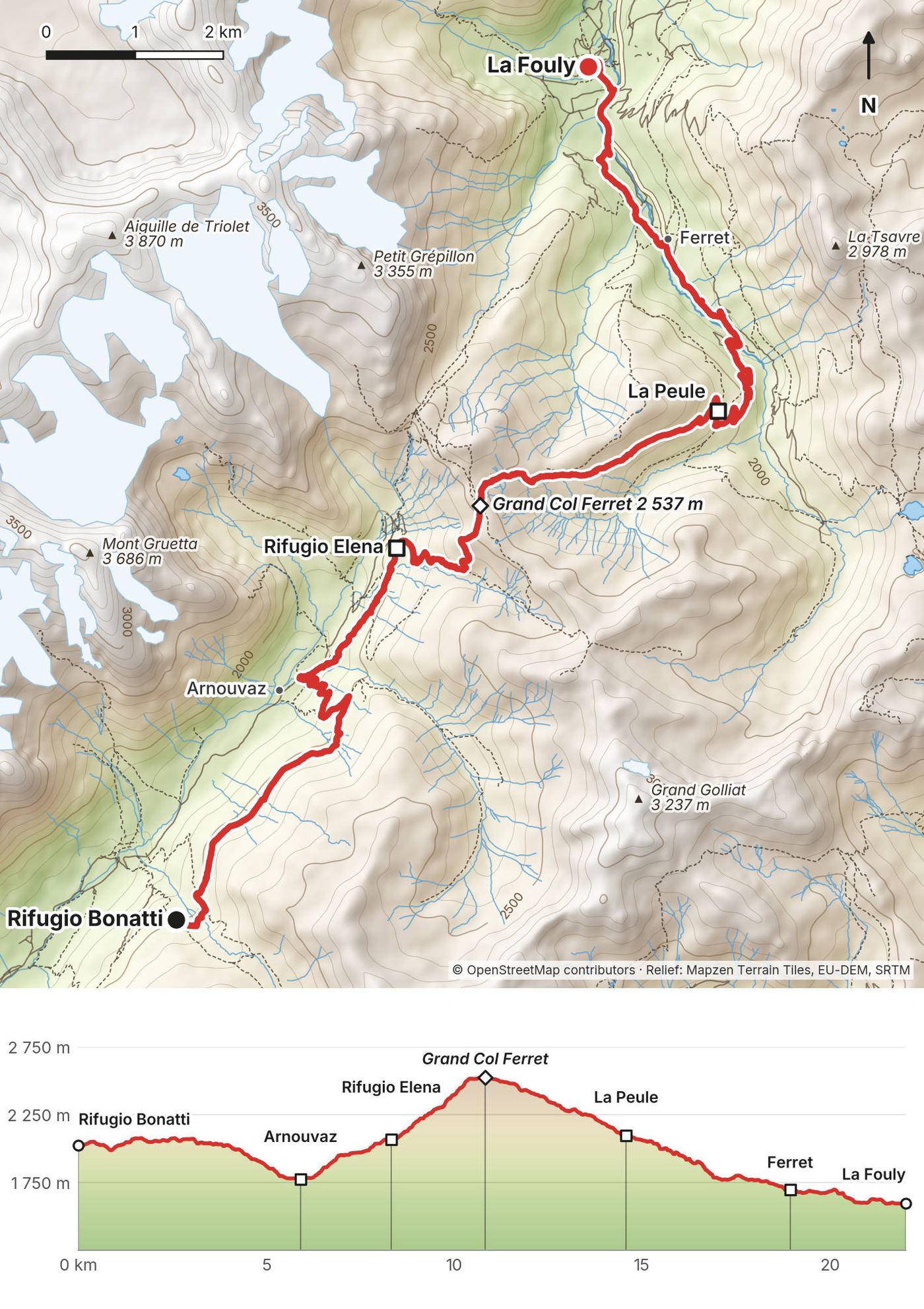
Day 6: Rifugio Bonatti to La Fouly
- Distance
- 13.7 mi (22.0 km)
- Climbing
- 3,119 ft (951 m)
- Descent
- 4,521 ft (1,378 m)
- Time to allow
- 8 to 9 hours
- High point
- Grand Col Ferret, 8,323 ft (2,537 m), the border with Switzerland
- Sleep
- La Fouly: Auberge des Glaciers or Auberge Maya-Joie; or La Peule (9.1 miles)
- Food and water
- Rifugio Elena (5.2 miles); La Peule (9.1 miles); Ferret; La Fouly
- Buses and lifts
- Val Ferret bus at Arnouvaz (Italy); TMR bus from Ferret and La Fouly to Orsières (Switzerland)
What I did here
In 2019 I left Bonatti at 11:23 a.m. on August 18, passed Arnouvaz at 1:56 p.m. and Rifugio Elena at 2:36, crossed the Grand Col Ferret at 3:27 and reached La Fouly at 7:08 p.m. That's your GPX line.
In 2022 we ran it the same way. On the climb: "One thing you get with the iPhone footage is you get to see just how tired I am going up these hills. I'm tired. But look at this, though. It's beautiful." And at the top: "We are in Switzerland."
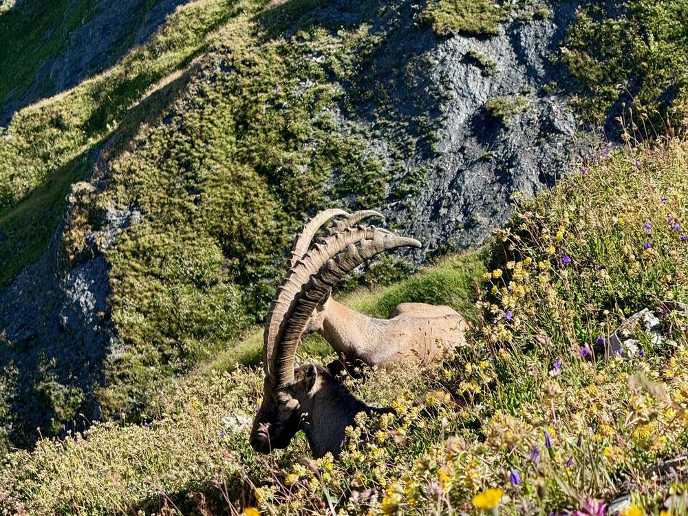
In 2026 the group took the bus to Arnouvaz and started at 8:15 a.m. We passed Elena at 8:56, saw ibex on the climb, were on the Grand Col Ferret at 10:34 and in La Fouly at 2 p.m.
The trail
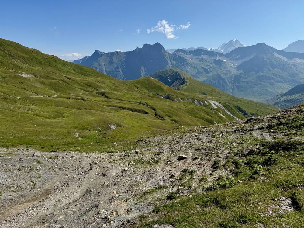
From Bonatti the path traverses and then drops to the valley floor at Arnouvaz, about 1,770 m, at 3.7 miles. It climbs past Rifugio Elena (5.2 miles), at the foot of the Pré de Bar glacier, and on up grassy switchbacks to the Grand Col Ferret, 2,537 m, at 6.7 miles: the highest pass of the classic route and the border with Switzerland.
The descent into Switzerland is long and easy: open slopes to the alp at La Peule (9.1 miles), a track down to the hamlet of Ferret (11.8 miles) and the valley path to La Fouly.
If you need to get off
Before the col, go down to Arnouvaz for the Val Ferret bus to Courmayeur. On the Swiss side, the TMR bus runs from Ferret (in summer) and La Fouly to Orsières, with trains to Martigny.
Watch this day
2019 film, the Grand Col Ferret · 2022 film, Day 4
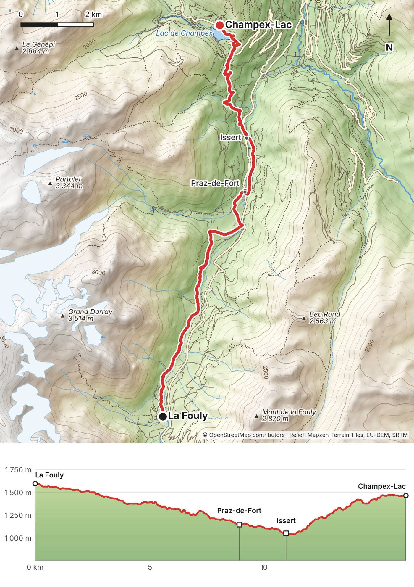
Day 7: La Fouly to Champex-Lac
- Distance
- 10.0 mi (16.2 km)
- Climbing
- 1,820 ft (555 m)
- Descent
- 2,262 ft (690 m)
- Time to allow
- 5.5 to 6.5 hours
- High point
- La Fouly, 5,243 ft (1,598 m), where you start
- Sleep
- Champex-Lac: Pension en Plein Air, hotels; or Relais d'Arpette above the village
- Food and water
- Villages all the way: Praz-de-Fort, Issert; shops and restaurants in Champex-Lac
- Buses and lifts
- TMR buses La Fouly to Orsières and Orsières to Champex-Lac
What I did here
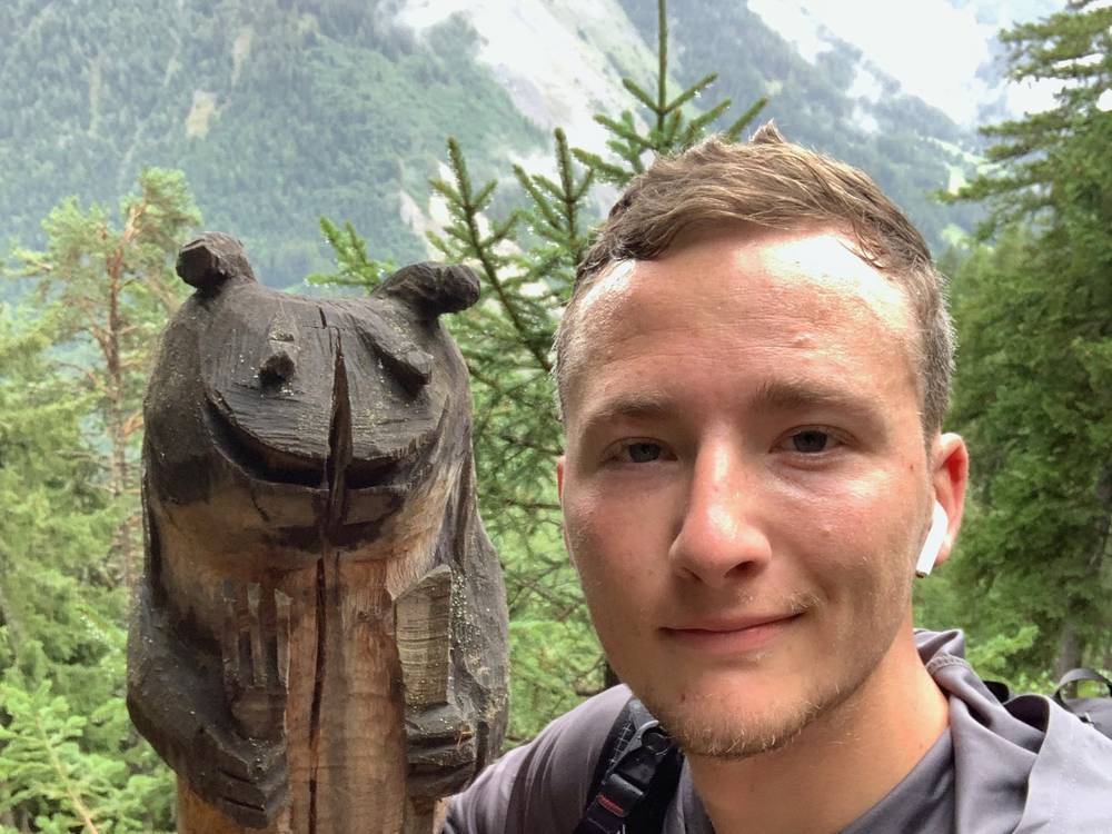
In 2019 this was my last morning, August 19. I left La Fouly at 9:08 a.m., walked down the valley and was in Champex-Lac at 1:10 p.m. I stopped for a selfie with a carved wooden bear on the climb.
In 2022 we ran from La Fouly to Trient in one go, over 20 miles: "Good morning. Day five." Later: "I just had coffee. My third apple tart of the day and a milkshake. My stomach is not agreeing with me."
In 2026 the group skipped this day and the next with a transfer from La Fouly to Trient, arranged by Vagabond Trails.
The trail
The easiest day. The path follows the Drance de Ferret down the Swiss Val Ferret through woods and meadows to Praz-de-Fort (5.5 miles) and Issert (6.8 miles), the low point at about 1,050 m. From Issert it climbs about 1,400 ft through the woods to the lake at Champex-Lac.
Diversion near Orsières. Since July 11, 2026, the path between Prayon and Branche (the Treutsebo sector) has been rerouted because of rockfall, and the old path is closed. My 2019 line follows the old path there. Follow the signs on the ground. The commune also reported in September 2026 that the path between Prayon and Saleinaz had reopened on its original line after debris flows in August.
If you need to get off
Every village on the way has a bus stop on the TMR line to Orsières, where trains go to Martigny.
Watch this day
2019 film, the last day · 2022 film, Day 5
Day 8: Champex-Lac to Trient
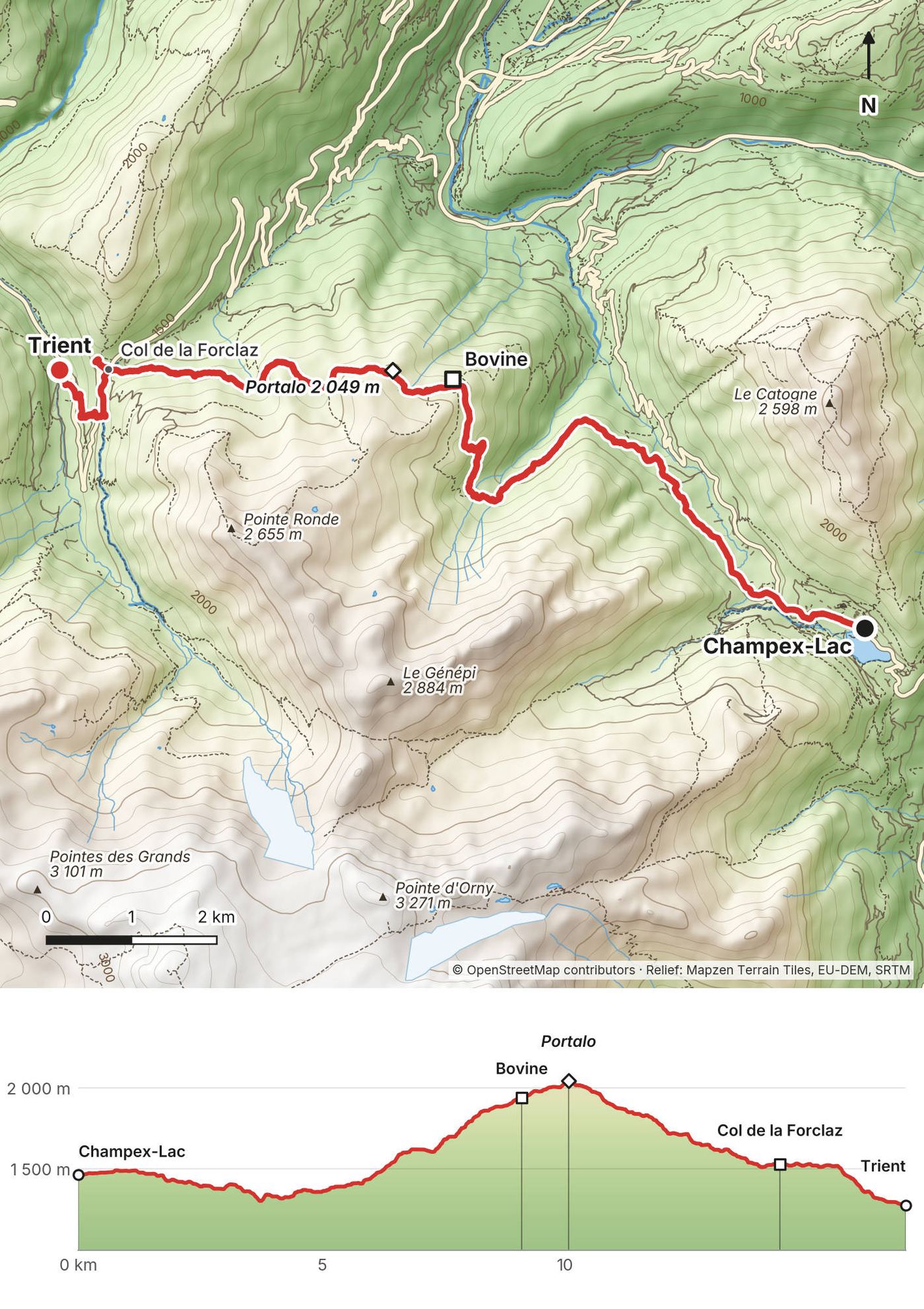
- Distance
- 10.5 mi (16.9 km)
- Climbing
- 2,658 ft (810 m)
- Descent
- 3,252 ft (991 m)
- Time to allow
- 6.5 to 7.5 hours
- High point
- Portalo, 6,722 ft (2,049 m), above the Bovine alp
- Sleep
- Trient: Auberge Mont-Blanc or Refuge Le Peuty; or the hotel at the Col de la Forclaz
- Food and water
- The Bovine alp (5.6 miles); the hotel at the Col de la Forclaz (8.9 miles); Trient
- Buses and lifts
- La Breya chairlift above Champex; TMR summer bus from the Col de la Forclaz to Trient and Le Châtelard
What I did here
In 2019 I left Champex-Lac at 1:10 p.m. on August 19, crossed the Bovine balcony, went over Portalo at 3:56, walked down through fog in the woods and reached the Col de la Forclaz at 5:09 p.m. My recording ends there; Trient, where I'd started, is 1.4 miles below.
In 2022 we ran the same way and down to Trient, where the group slept. Your GPX uses my 2022 line for the last stretch into Trient.
The trail
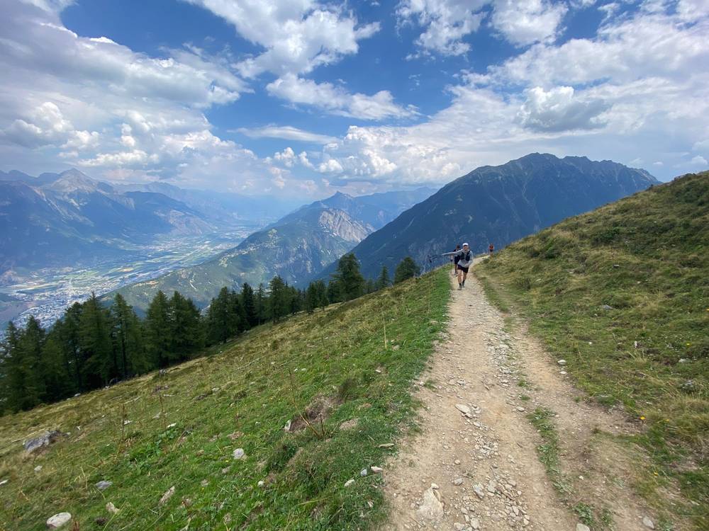
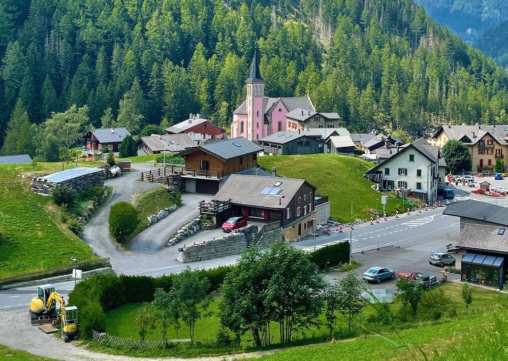
From Champex-Lac the path descends gently to Plan de l'Au (2.7 miles), then climbs steadily through forest to the Bovine alp, about 1,940 m on my GPS (5.6 miles). The path traverses high above Martigny and the Rhône valley to Portalo, 2,049 m, then drops through the woods to the Col de la Forclaz (8.9 miles), a road pass with a hotel. A path along the forest leads down to Trient.
Fenêtre d'Arpette variant. The official variant climbs from Champex through the Val d'Arpette to the Fenêtre d'Arpette, 2,665 m, and down past the Trient glacier. The official site calls it harder, for seasoned hikers, and says "in bad weather, mist, wet ground or advanced fatigue, the classic route is the wiser choice." I haven't walked it; none of my GPS files follow it.
If you need to get off
From Champex, buses go to Orsières. At the Col de la Forclaz, the TMR summer bus goes to Trient and Le Châtelard (for the train to Martigny or Chamonix), and postbus line 12.213 runs down to Martigny (check its 2027 timetable).
Watch this day
2019 film, Bovine · 2022 film, Day 5
Day 9: Trient to Tré-le-Champ
- Distance
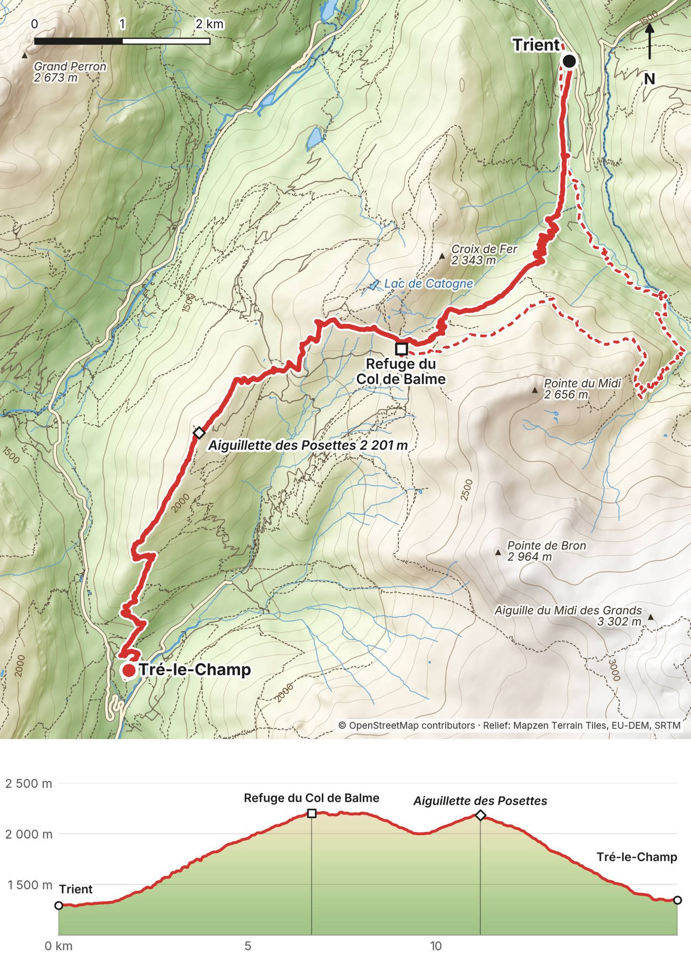
- 10.2 mi (16.3 km)
- Climbing
- 3,645 ft (1,111 m)
- Descent
- 3,481 ft (1,061 m)
- Time to allow
- 7.5 to 8.5 hours
- High point
- Aiguillette des Posettes, 7,221 ft (2,201 m); the Col de Balme, 2,191 m, is the border with France
- Sleep
- Tré-le-Champ: Gîte Le Moulin (€51.20 half board, 2026) or Auberge La Boërne; or Argentière
- Food and water
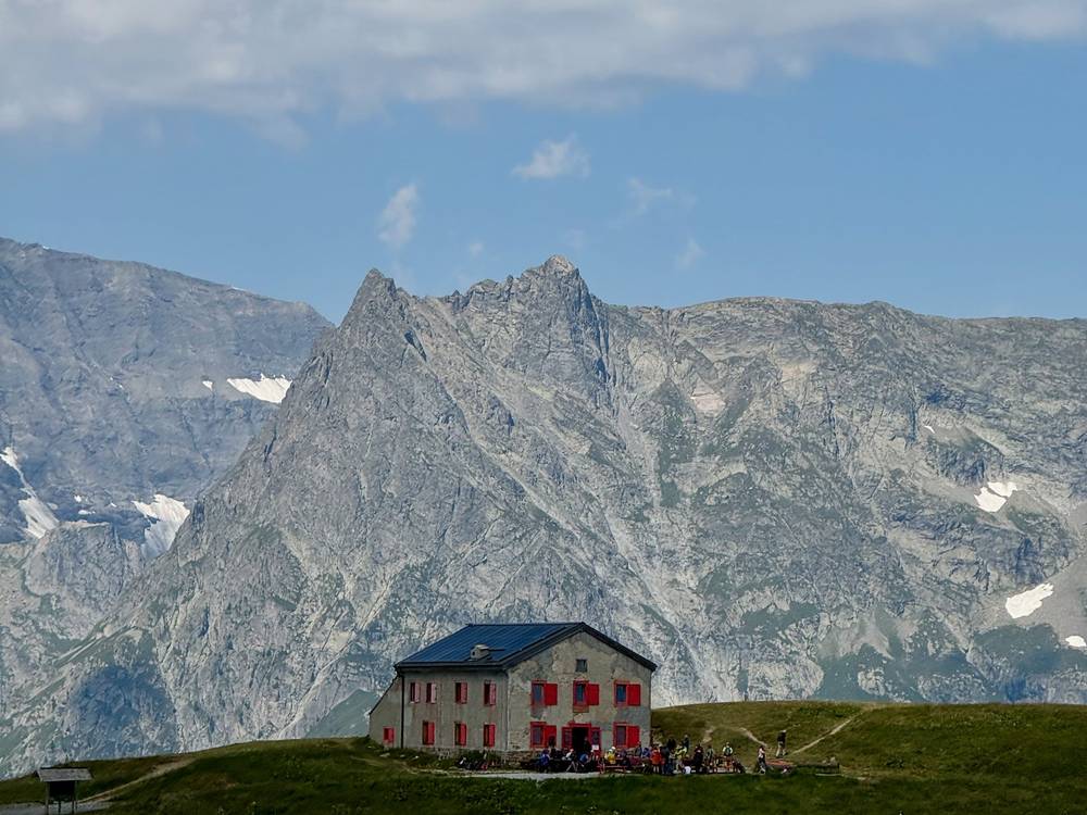
- Refuge du Col de Balme (4.3 miles); then nothing until Tré-le-Champ
- Buses and lifts
- Le Tour lifts from the Col de Balme area; train at Montroc; bus 2 from Le Tour
What I did here
In 2019 this was my first day. I walked up from Martigny, left Trient at 4:09 p.m. on August 14, was at the Col de Balme at 6:19 and on the Aiguillette des Posettes at sunset, and got to Tré-le-Champ at 8:55 p.m. The thumbnail of my 2019 film is on the Posettes ridge.
In 2022 this was the start of our last day: "This is it. Last day. Day six. Got about 20 miles down to Chamonix."
In 2026 we took the Les Grands variant from Trient to the Col de Balme (8:08 to 11:40 a.m.), went over the Tête de Balme and finished at Le Buet.
The trail
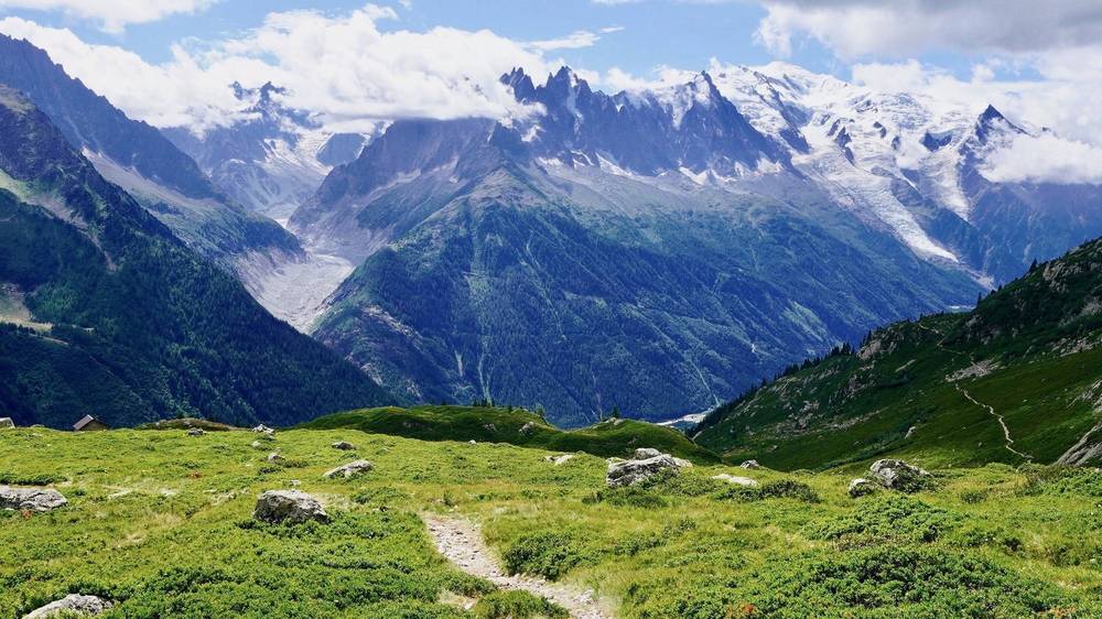
From Trient the path climbs through forest and pasture, about 2,900 ft in 4.3 miles, to the Col de Balme, 2,191 m, on the French border, with the refuge right on the col. The whole Chamonix valley opens up here, with Mont Blanc at the far end.
The main route in this guide then follows my 2019 line: past the Col des Posettes (6.0 miles) and up along the ridge to the Aiguillette des Posettes, 2,201 m (6.9 miles), then a steep descent through the woods to Tré-le-Champ. The official main route drops straight from the Col des Posettes; the Aiguillette adds a short climb and the best view of the day.
Les Grands variant (my 2026 line, in the GPX): up the Trient valley to the Les Grands hut below the Trient glacier, then across the slopes to the Col de Balme. 7.0 miles to the col with 3,481 ft of climbing.
If you need to get off
From the Col de Balme, walk down to Charamillon for the gondola to Le Tour, where bus 2 goes to Chamonix. From the Col des Posettes, a path drops to Le Tour.
Watch this day
2019 film, Day 1: Trient to Tré-le-Champ · 2022 film, Day 6
Day 10: Tré-le-Champ to La Flégère
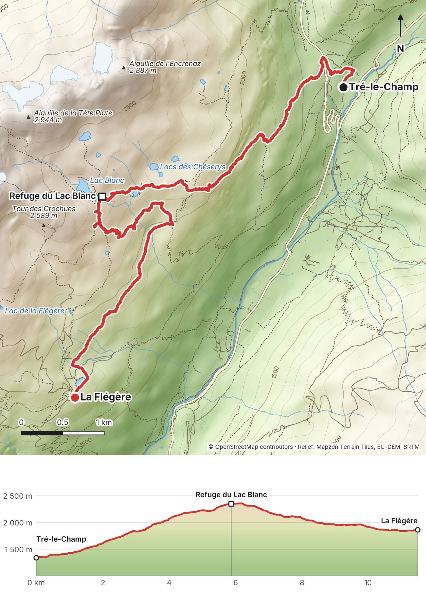
- Distance
- 7.1 mi (11.5 km)
- Climbing
- 3,445 ft (1,050 m)
- Descent
- 1,761 ft (537 m)
- Time to allow
- 5.5 to 6.5 hours
- High point
- Lac Blanc, 7,717 ft (2,352 m)
- Sleep
- Refuge de la Flégère; or Refuge du Lac Blanc (3.6 miles in, book direct, cash only)
- Food and water
- Refuge du Lac Blanc; La Flégère at the end. No water on the climb.
- Buses and lifts
- La Flégère cable car down to Les Praz (summer)
What I did here
In 2019 I left Tré-le-Champ at 9:24 a.m. on August 15, passed the Lacs des Chéserys, was at Lac Blanc at 11:35 and at La Flégère at 1:27 p.m., and kept going to Les Houches the same day: 20 miles.
In 2022 we came through here on the last day, "into the preserve, past the little lakes," and stopped at the Refuge du Lac Blanc for lunch before running down to La Flégère. There I finished: "Well, cost $16, but I took the gondola down. I'm tired. I'm done. Ran 100 miles, though, so there's that."
The trail
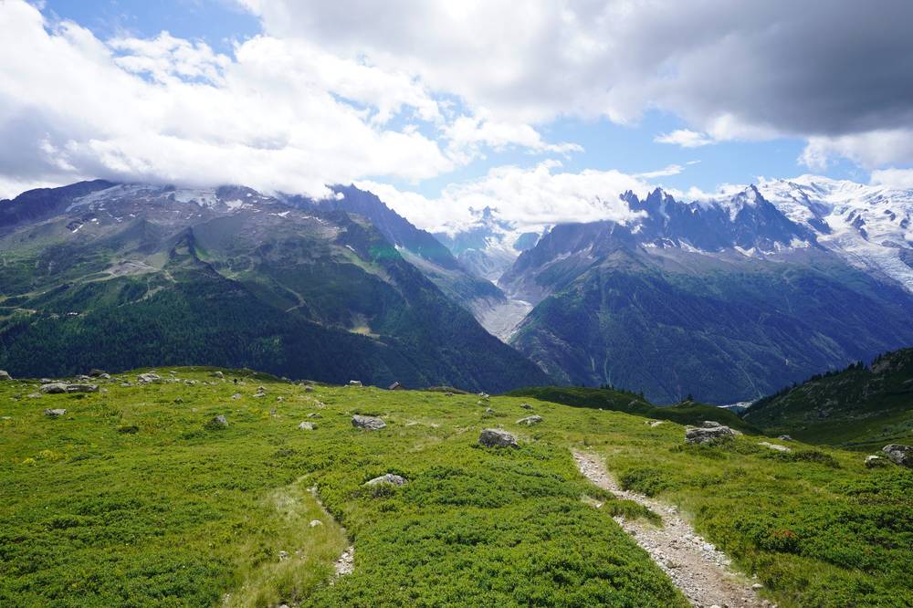
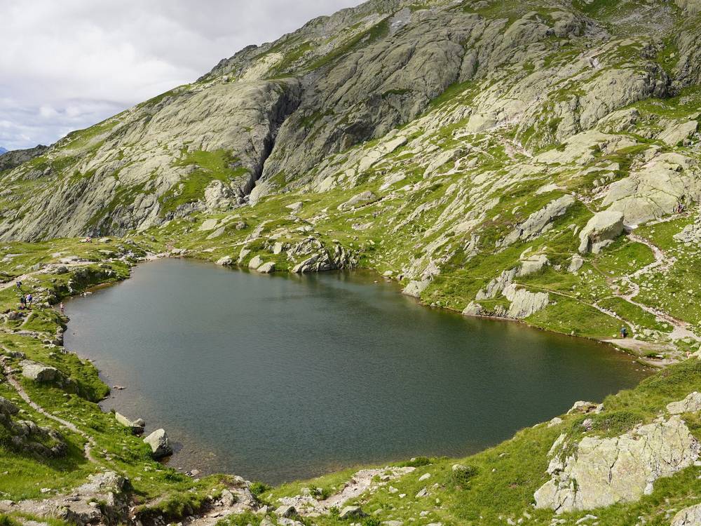
The route climbs from Tré-le-Champ into the Aiguilles Rouges nature reserve. Near the Aiguillette d'Argentière (2.0 miles) the path goes up a series of ladders and metal steps set into the rock. Above them, it crosses the Tête aux Vents and passes the Lacs des Chéserys to Lac Blanc, 2,352 m, at 3.6 miles, facing the Aiguilles and Mont Blanc across the valley.
From Lac Blanc a busy path drops to La Flégère, 1,877 m, at the top of the cable car from Les Praz.
The ladders. They're short but steep. If you don't like heights, or there's still snow, ride the cable car up to La Flégère and walk up to Lac Blanc from there, as La Chamoniarde advised in June 2026.
Nature reserve. Lac Blanc is in the Aiguilles Rouges nature reserve. No camping there except at booked bivouac pitches, and never at Lac Blanc itself.
If you need to get off
La Flégère's cable car goes down to Les Praz, on bus line 1 to Chamonix and Les Houches.
Watch this day
2019 film, Day 2: Lac Blanc · 2022 film, the last day
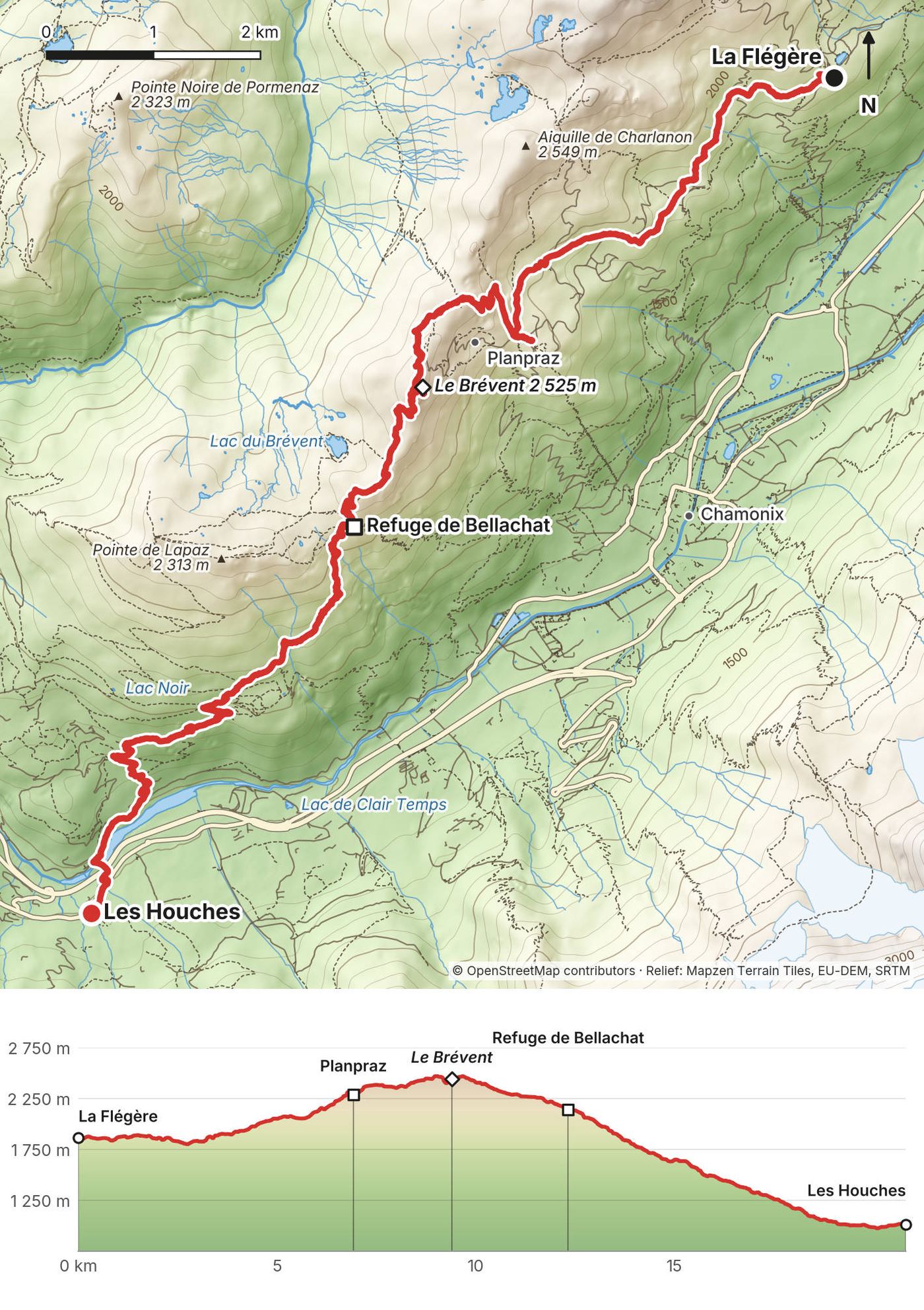
Day 11: La Flégère to Les Houches
- Distance
- 12.9 mi (20.8 km)
- Climbing
- 2,748 ft (838 m)
- Descent
- 5,508 ft (1,679 m)
- Time to allow
- 8 to 9 hours
- High point
- Le Brévent, 8,284 ft (2,525 m)
- Sleep
- Les Houches or Chamonix; or Refuge de Bellachat (7.6 miles, book direct)
- Food and water
- Planpraz (about 3 miles); Refuge de Bellachat (7.6 miles)
- Buses and lifts
- Planpraz and Brévent lifts to Chamonix (summer); bus 1 and the train from Les Houches
What I did here
In 2019 I walked the balcony from La Flégère to Planpraz after lunch on August 15, went up over the Col du Brévent and the summit of the Brévent at 5:31 p.m., passed the Refuge de Bellachat at 6:28 and got down to Les Houches at 8:50 p.m., 20 miles after leaving Tré-le-Champ that morning.
In 2022 and 2026 we finished in Chamonix and didn't walk this stretch.
The trail
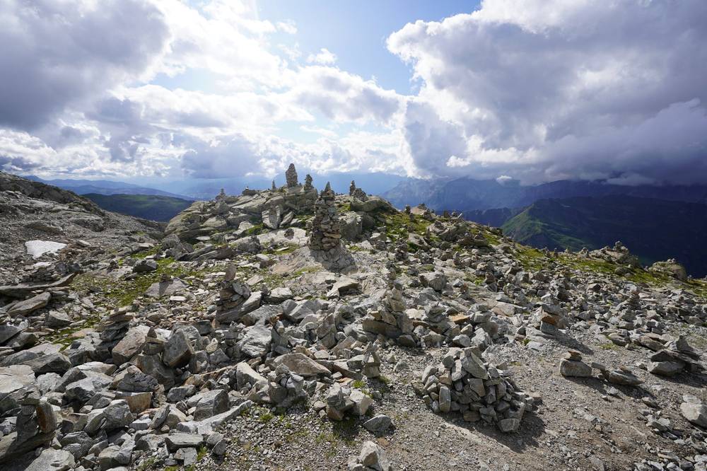
From La Flégère the path traverses the slopes above Chamonix, past the ski lifts at Planpraz (about 3 miles), then climbs to the Col du Brévent, 2,368 m (4.5 miles), and up to the summit of the Brévent, 2,525 m (5.8 miles), where the view across to Mont Blanc is the best of the loop. The official route skips the summit.
Then comes the longest descent of the TMB: past the Refuge de Bellachat, 2,136 m (7.6 miles), and down about 3,700 ft of steep, rocky, then wooded path to Les Houches. Save your knees for it. If you're done, take the Brévent cable car and the Planpraz gondola down to Chamonix instead.
If you need to get off
From Planpraz or the Brévent summit, the lifts go down to Chamonix. After Bellachat there's no way off but down.
Watch this day
Other ways to do it
Join days (9 or 10 days)
- 10 days: join Days 10 and 11, Tré-le-Champ to Les Houches, 20 miles. I did exactly that in 2019. Or cut Day 11 short with the Planpraz lift down to Chamonix.
- 9 days: also join Days 7 and 8, La Fouly to Trient, 20.5 miles. We ran that in 2022. Or take the bus from La Fouly to Champex-Lac and walk only Day 8.
- The Val Veny low route and the Courmayeur buses make Day 4 shorter; the lifts at Bellevue, Planpraz and La Flégère shave climbs off Days 1, 10 and 11.
The variants I walked
| Variant | Replaces | Mi (km) | My trip |
|---|---|---|---|
| Col de Tricot | Bellevue to Les Contamines on Day 1 | 8.2 (13.2) | 2022, 2026 |
| Col des Fours | Croix du Bonhomme to Mottets on Days 2 and 3 | 5.2 (8.3) | 2019, 2022 |
| Val Veny low route | Elisabetta to La Visaille on Day 4 | 4.5 (7.2) | 2026 |
| Les Grands | Trient to the Col de Balme on Day 9 | 7.0 (11.2) | 2026 |
Each one is a separate GPX file. The official site also lists the Tête Bernarda (Day 5), the Fenêtre d'Arpette (Day 8), Vallorcine and Le Tour variants; I haven't walked those.
Short on time: the six-day highlights
In 2026 the group walked the highlights in six days, with Vagabond Trails handling lifts and transfers between trailheads: Bellevue to Les Contamines over the Col de Tricot; Notre-Dame de la Gorge to Les Chapieux; La Ville des Glaciers over the Col de la Seigne to La Visaille; Courmayeur to Bonatti and down to Lavachey; Arnouvaz over the Grand Col Ferret to La Fouly; Trient over the Col de Balme to Le Buet. That's 63 miles of walking. You can copy it on your own with the lifts and buses in this guide, except the La Fouly to Trient transfer, which by public transport is a bus to Orsières, the train to Martigny and a postbus up to Trient.
Start somewhere else
It's a loop. Courmayeur, Champex-Lac and Trient are good starts if you come from Italy or Switzerland. In 2019 I started in Trient.
Getting home
From Les Houches take the Mont-Blanc Express down to Saint-Gervais-Le Fayet and the Léman Express to Geneva, or bus 1 or the train up to Chamonix for the buses and shuttles to Geneva Airport (FlixBus listed at least four a day in 2026).
What I did. In 2022 and 2026 I took a shared shuttle from Chamonix to Geneva Airport the morning after we finished: in 2022 from Chamonix at 9:55 a.m., in 2026 from Chamonix Sud at 11:30 a.m. for an afternoon flight. In 2019 I finished at the Col de la Forclaz above Trient.
If you end in Switzerland or Italy, Martigny has trains to Geneva and its airport, and Courmayeur has buses through the Mont Blanc Tunnel to Chamonix (reservation required; two a day each way in autumn 2026).
What it costs
Refuges. The official FAQ gives €65 to €95 a night for half board in a dorm, and €500 to €900 for the beds and meals on a 7 to 10 day trek. The 2026 prices I could confirm: Gîte Le Pontet €54.20, Refuge des Mottets €60 (large dorm), Gîte Le Moulin €51.20, Refuge de Bellachat €60 (pending approval), Refuge de Miage €80, Rifugio Bertone €70, Rifugio Elena €70, Rifugio Bonatti €75, Refuge du Col de Balme €62 or CHF 62. Prices in The refuges.
My costs. In 2019 I didn't keep receipts. What I said afterwards: refuges were "maybe 50 to 100 dollars," hotels in the towns "anywhere from 100 to 300 dollars," and "it could be an expensive trip if you stay in the refuges, hotels and you eat food, you drink beer every place you can, or you could go the cheap route: stay in campsites, go with groceries, cook your own food." In 2022 and 2026 the operator paid for my beds and meals, so I have no costs to share from those trips.
For your budget, 11 nights (2026 prices):
| Item | Estimate |
|---|---|
| 11 nights half board, mostly dorms | about €800 to €950 |
| Picnic lunches or café lunches | about €12 to €20 a day |
| Drinks, snacks, showers, liners | about €10 a day |
| Buses and lifts (a few) | €20 to €80 |
| Geneva to Les Houches and back | €60 to €100 by train or bus |
| Swiss nights | in francs, often a little more |
Insurance with mountain rescue cover matters: in Valais the rescued person is billed.
The refuges
Where to sleep at the end of each day, and the alternatives. Half-board prices are per person in a dorm; "2026" means the refuge dated it 2026; other prices were shown in September 2026 with no year. Book on the TMB platform unless it says direct.
| Day end | Place | Half board | Cards | Book |
|---|---|---|---|---|
| 1 | Gîte Le Pontet, Les Contamines | €54.20 (2026) | Yes | Platform |
| 1 | Refuge de Nant Borrant | €60 (2026) | No | Platform |
| 1 | Refuge de la Balme | €71 (listed with its 2027 dates) | No | Platform |
| 2 | Auberge-Refuge de la Nova, Les Chapieux | from €72 | No | Platform |
| 2 | Les Chambres du Soleil, Les Chapieux | €75 | Yes | Platform |
| 3 | Refuge des Mottets | €60 (2026) | No | Platform |
| 3 | Rifugio Elisabetta | €58 (2024 card; €46 CAI) | No | Direct |
| 4 | Rifugio Maison Vieille | €80 (2026) | Yes | Platform |
| 5 | Rifugio Bertone | €70 | Yes | Platform |
| 5 | Rifugio Bonatti | €75 (2026) | Sometimes | Direct |
| 6 | Rifugio Elena | €70 (2026) | Unreliable | Direct |
| 6 | Gîte Alpage de La Peule | CHF 90 | Yes | Platform |
| 6 | Auberge Maya-Joie, La Fouly | from CHF 84 plus dinner | Yes | Platform |
| 7 | Relais d'Arpette, Champex | CHF 83 | Yes | Platform |
| 8 | Auberge Mont-Blanc, Trient | CHF 70 | Yes | Platform |
| 8 | Refuge Le Peuty, Trient | CHF 67 | Yes | Platform |
| 9 | Gîte Le Moulin, Tré-le-Champ | €51.20 (2026) | Yes | Platform |
| 9 | Auberge La Boërne, Tré-le-Champ | €60 | Yes | Platform |
| 10 | Refuge du Lac Blanc | €90 | Deposit only; cash on site | Direct |
| 10 | Refuge de la Flégère | €72 | Yes, not Amex | Direct |
| 11 | Refuge de Bellachat | €60 (2026) | Not stated | Direct |
Also on the route: Refuge du Col de Balme (Day 9, €62 or CHF 62, only 10 to 12 beds, book direct), Cabane du Combal (Day 4, rooms only, book direct), Hotel Lavachey (below Bonatti, rooms from €80 half board), Auberge des Glaciers (La Fouly), Pension en Plein Air (Champex, cash), and the hotel at the Col de la Forclaz (CHF 74 dorm). In Courmayeur, Les Houches and Chamonix there are hotels of every kind.
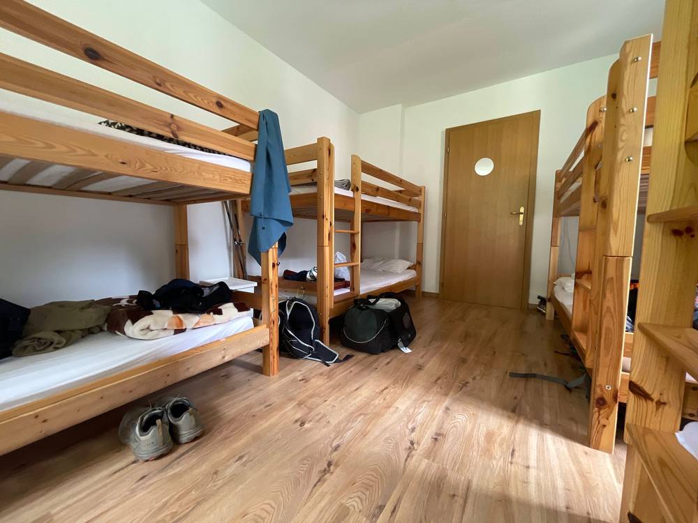
Things every refuge wants. A sleeping-bag liner (most sell them). Arrive by 6 p.m. or call; dinner is at about 7. Bedbug rules: boots and packs often stay out of the dorms. No showers at Lac Blanc or Bellachat, and paid or token showers in some others.
Camping and bivouac (official TMB site, 2026):
- France: Les Houches and Saint-Gervais tolerate one night, sunset to sunrise. Chamonix bans it except high bivouac; never at Lac Blanc or the Col des Posettes. Les Contamines has booked bivouac areas (reserve-bivouac74.fr). Nothing at Lac Jovet and Plan Jovet from July 1 to August 30. The official TMB site says bivouac isn't allowed in the Vallée des Glaciers; in 2026 the tourist office listed paid camping at La Ville des Glaciers (€5 a tent a night).
- Italy: camping banned; bivouac only above 2,500 m. Fine €566.
- Switzerland: campsites only in Orsières commune (La Fouly, Champex, Relais d'Arpette); in Trient, the Le Peuty and Col de la Forclaz sites.
Gear for this route
What a hut-to-hut TMB needs
- A 25 to 35 liter pack; you don't carry food or a tent
- A sleeping-bag liner (required almost everywhere) and earplugs
- Rain jacket and a warm layer: the passes are over 2,300 m and can be cold or wet any month
- Shoes with good grip; poles help on the long descents (Days 4, 6 and 11)
- Sun hat, sunglasses and sunscreen
- Two 1 liter bottles: fill up at refuges and in villages
- Cash in euros and Swiss francs, plus a card
- Passport or ID (you cross two borders on foot)
- Phone with offline maps and the GPX files, and a power bank
- Headlamp, small first-aid kit, blister care
- In June or early July, light crampons or microspikes: snow can linger on the Col du Bonhomme
Paid links: I earn a commission if you buy through these links, at no extra cost to you. As an Amazon Associate I earn from qualifying purchases.
I've done this loop three times: solo with a small pack in 2019, running in 2022, and hiking with my bags sent ahead in 2026. No tent or stove needed. Here's what I carried, what I'd take now, and what I filmed with.
What I carried
- Pack (2019): a small pack. Mine was much smaller than some people's, even with a camera.
- Stove (2019): none. I did not cook my food. I bought bread, sausages, cheese and Twix in towns and ate a proper meal at restaurants and refuges.
- Navigation (2019): my phone with AllTrails, and audiobooks
- Running (2022): a running vest with water, and poles. The operator moved our bags between nights.
- Hiking (2026): a daypack and an umbrella. Our luggage went ahead each day with the operator. On sunny days I walked with the umbrella for shade.
What I'd take now
My current kit for a hut-to-hut TMB.
- Pack: Hyperlite Mountain Gear Waypoint 35 (Hyperlite). 25 to 35 liters is plenty: you don't carry food or a tent.
- Sleeping-bag liner: Naturehike ZY20 Sleeping Bag Liner (Amazon). Required almost everywhere.
- Rain shell: Arc’teryx Beta AR Jacket (Arc’teryx). The passes are over 2,300 m and can be cold or wet any month.
- Warm layer: Arc’teryx Cerium Hoody (Arc’teryx)
- Shoes: Oboz Katabatic LT Low GTX (Amazon). Shoes with good grip.
- Poles: Black Diamond Alpine Carbon Z Poles (Amazon). They help on the long descents (Days 4, 6 and 11).
- Umbrella: Six Moon Designs Silver Shadow Carbon (Amazon). Shade on sunny days, as I did in 2026.
- Sun hat: PATH Projects Muir Cap 2.0 (PATH Projects)
- Sunglasses: Goodr OG Sunglasses (Amazon)
- Microspikes: Yatta Life Ice Spikes (Amazon). In June or early July: snow can linger on the Col du Bonhomme.
- Headlamp: Nitecore NU20 Classic (Amazon)
- Power bank: Nitecore NB20000 (Amazon)
- Navigation: AllTrails+ (AllTrails, 30% off). Import my GPX files and download them offline. Offline maps need the paid plan.
- Phone data: Airalo eSIM (Airalo, $3 off). Mobile data without a SIM swap. There's no signal from above Les Contamines to Lac Combal.
Filming kit
What I filmed with: the 2019 film on a Sony with a drone, the 2022 run on an iPhone and a drone. My setup is smaller now (below). Check the drone rules in Weather and safety before you fly: the reserves and parks on the route have their own.
- Camera (2019): Sony a7 III (Amazon)
- Lens (2019): Sony FE 16-35mm f/2.8 GM (Amazon)
- Drone (2019): DJI Mavic 2 Pro. No longer made.
- Phone (2022): Apple iPhone 12 Pro Max
- Drone (2022): DJI Air 2S (Amazon), now the Air 3S
What I film with now
Since September 2026 I film with a smaller setup: the Pocket 4 and the Mic 3 on the trail, and the Mini 5 Pro in the air.
- Camera: DJI Osmo Pocket 4 (Amazon)
- Mic: DJI Mic 3 · 1 TX + 1 RX (Amazon). It pairs with the Pocket 4.
- Drone: DJI Mini 5 Pro (Amazon)
Weather and safety
Forecast. Use a mountain forecast for about 2,500 m, not the valley. Météo-France mountain for France, MeteoSwiss for Switzerland and the Aosta Valley weather centre for Italy. Storms mostly come between 2 and 5 p.m.: start early on pass days. For trail conditions, ask the refuge wardens, or the Office de Haute Montagne in Chamonix (La Chamoniarde): +33 4 50 53 22 08, chamoniarde.com.
Emergency numbers. 112 works in all three countries.
- France: 112 or 15 (medical). Mountain rescue is the PGHM: Chamonix +33 4 50 53 16 89 (Haute-Savoie), Bourg-Saint-Maurice +33 4 79 07 01 10 (the Chapieux side).
- Italy (Aosta Valley): 112 covers medical and mountain rescue.
- Switzerland (Valais): 144. Rega is 1414, but in Valais rescues go through 144. The rescued person is billed, even if someone else called.
- No signal from above Les Contamines to Lac Combal (Days 2 to 4). Tell someone your plan.
Where to be careful:
- The rocky last climb to the Col du Bonhomme and the traverse to the Croix du Bonhomme (Day 2), with snow into July
- The Col des Fours variant: high, exposed, only in clear weather
- The steep descent from the Col Chécrouit to Dolonne (Day 4)
- The ladders below Lac Blanc (Day 10)
- The long, rocky descent from the Brévent to Les Houches (Day 11)
- Afternoon thunderstorms on any pass
Going solo. I did it alone in 2019 and I said it's "very developed and very accessible." You're rarely far from a refuge or a village in summer.
Drones. The nature reserves and parks on the route have their own rules, and each country has national drone rules. Check them all before you bring one.
Using the GPX files
Cut from my own GPS recordings of 2019, 2022 and 2026, with all timestamps removed.
| File | What it is |
|---|---|
| tmb-day-01.gpx to tmb-day-11.gpx | One file per day of the 11-day plan |
| tmb-variant-...gpx | The four variants: Col de Tricot, Col des Fours, Val Veny, Les Grands |
| tmb-full-loop.gpx | Every day and variant, with waypoints for refuges, passes, towns and bus stops |
The Les Chapieux road on Day 3 is traced from OpenStreetMap; near Orsières (Day 7) my 2019 line follows a path rerouted in July 2026.
AllTrails. On a computer, sign in at alltrails.com, create a new map and use Import. It then shows up in the app on your phone. Offline maps need a paid plan.
Gaia GPS. Open the file from Files, email or AirDrop and choose Gaia GPS, or use Import on gaiagps.com. Download the map area offline.
Garmin. In Garmin Connect on the web, go to Training, Courses, Import. Save it as a course and send it to your watch.
Organic Maps (free). Download the offline maps for Haute-Savoie, Savoie, Aosta Valley and Valais, then open the GPX file and choose Organic Maps. Before you leave, turn on airplane mode and check that each day and your location show up.
Before you go, check these
These change every year. Everything else in this guide stays the same.
Refuges
- Book on the TMB platform from October 15, 2026; book the direct-only refuges (Elisabetta, Bonatti, Elena, Lac Blanc, La Flégère, Bellachat, Col de Balme) on their own dates
- Each refuge's opening and closing dates for 2027, and 2027 prices
- The Croix du Bonhomme refuge (closed until 2029) and whether the path past the works is open
Trail conditions
- Snow on the Bonhomme, the Col des Fours and the Fenêtre d'Arpette before mid-July
- The Treutsebo diversion near Orsières (Day 7) and any other closures on autourdumontblanc.com
- The official conditions notices, the OHM in Chamonix and the refuge wardens
Buses and lifts
- 2027 timetables for the Chapieux shuttle, the Courmayeur buses, the Swiss TMR buses and the Martigny to Trient postbus
- Lift season dates, and which Courmayeur lifts are open after the 2026 works
- Train and bus times from Geneva, and whether you need a reservation for the Courmayeur to Chamonix bus (and the 2027 tunnel closure)
Your stuff
- A sleeping-bag liner, cash in euros and Swiss francs, a passport or ID
- Insurance with mountain rescue cover
- Offline maps and the GPX files on your phone
One-page trip sheet
| Day | mi (km) | From, to | Sleep | Up (ft) |
|---|---|---|---|---|
| 1 | 11.2 (18.0) | Les Houches to Les Contamines | Les Contamines | 3,431 |
| 2 | 13.0 (21.0) | Les Contamines to Les Chapieux | Les Chapieux | 4,377 |
| 3 | 9.0 (14.4) | Les Chapieux to Elisabetta | Rifugio Elisabetta | 3,348 |
| 4 | 11.6 (18.6) | Elisabetta to Courmayeur | Courmayeur | 1,765 |
| 5 | 7.8 (12.5) | Courmayeur to Bonatti | Rifugio Bonatti | 3,430 |
| 6 | 13.7 (22.0) | Bonatti to La Fouly | La Fouly | 3,119 |
| 7 | 10.0 (16.2) | La Fouly to Champex-Lac | Champex-Lac | 1,820 |
| 8 | 10.5 (16.9) | Champex-Lac to Trient | Trient | 2,658 |
| 9 | 10.2 (16.3) | Trient to Tré-le-Champ | Tré-le-Champ | 3,645 |
| 10 | 7.1 (11.5) | Tré-le-Champ to La Flégère | La Flégère | 3,445 |
| 11 | 12.9 (20.8) | La Flégère to Les Houches | Home | 2,748 |
| Total | 117.0 (188.3) | 33,800 |
Passes: Col de Voza 1,653 m · Col du Bonhomme 2,329 m · Croix du Bonhomme 2,479 m · Col de la Seigne 2,516 m · Arête du Mont-Favre 2,442 m · Grand Col Ferret 2,537 m · Portalo 2,049 m · Col de Balme 2,191 m · Brévent 2,525 m
Booking: montourdumontblanc.com opens October 15, 2026. Direct: Elisabetta, Bonatti, Elena, Lac Blanc, La Flégère, Bellachat, Col de Balme.
Getting there and home: Geneva, then the Léman Express and Mont-Blanc Express to Les Houches, or a bus or shuttle to Chamonix. See Getting there.
Money: euros in France and Italy, Swiss francs in Switzerland; bring cash for the cash-only refuges.
Emergency: 112 everywhere · France 15, PGHM Chamonix +33 4 50 53 16 89 · Valais 144 · Rega 1414
About this guide
Tour du Mont Blanc Hiking Guide: 11 days hut to hut around Mont Blanc, by Kraig Adams. 2027 season edition, updated September 2026.
I walked the Tour du Mont Blanc alone in August 2019 and made a film about it: Hiking 120 miles Alone on the Tour Du Mont Blanc. I came back in August 2022 to run it with a group, Trail Running 120 miles on the Tour Du Mont Blanc in the Alps, and again in July 2026 to hike the highlights with another group. Both group trips were run by Vagabond Trails. Everything in first person comes from those trips, my recordings and my films. Refuge, bus, lift and rescue facts were checked in September 2026 on official sites, and anything that changes yearly is dated.
Updates and contact. If something has changed, or you spot a mistake, email me at kraig@kraigadams.com.
Paid links, no sponsors. The gear links in this guide are paid links: I earn a commission if you buy through them, at no extra cost to you. Nobody paid for a mention in this guide, and it isn't sponsored.
Safety. Hiking in the Alps has real risks: weather, snow, steep ground and long days. This guide describes my trips and what I found, not current conditions. Trails, rules, prices and timetables change. Check the weather, follow local rules and signs, and turn back when conditions aren't right. You're responsible for your own safety.
Copyright. © 2026 Kraig Adams. This guide, its photos and the GPX files are for your personal use. Please don't share or resell them.
Credits. Photos are mine, from my three trips. GPX files are cut from my own recordings; the Les Chapieux to La Ville des Glaciers road is traced from OpenStreetMap. Maps © OpenStreetMap contributors, openstreetmap.org/copyright (ODbL). Relief: Mapzen Terrain Tiles, from SRTM and EU-DEM, produced using Copernicus data funded by the EU.
The details
- Format
- A 77-page PDF sized for a phone (A5, prints fine too) and a folder of GPX files, in one zip download.
- Edition
- 2027 season edition, updated September 2026.
- Questions
- Email kraig@kraigadams.com.
Questions
- How many days do you need for the Tour du Mont Blanc?
- The official site says 7 to 12, usually 10 to 11 stages. This guide splits it into 11 days of 7 to 14 miles. In 2019 I did the loop alone in five and a half days, but I was going fast.
- When is the best time to hike the Tour du Mont Blanc?
- Mid-June to mid-September, when the passes are clear and the refuges are open. July 14 to August 15 is the busiest stretch. My trips were in July and August, with clear, warm days.
- When do Tour du Mont Blanc refuge bookings open for 2027?
- Bookings for summer 2027 open on the official platform, montourdumontblanc.com, on October 15, 2026. A few refuges, like Elisabetta and Bonatti, book on their own sites. Book the smallest refuges first.
- Can you camp on the Tour du Mont Blanc?
- Only in a few places. Italy bans camping, and bivouac below 2,500 m, Switzerland mostly bans it outside campsites, and France allows a one-night bivouac in some communes.
- How do you get to the start of the Tour du Mont Blanc?
- Fly to Geneva. Shared shuttles and FlixBus reach Chamonix in about 1.5 hours, or take the train via Saint-Gervais to Les Houches. It's a loop, so you finish where you started.
Timeline · newest first
Published · September 26, 2026
Wrote the guide
The day-by-day guide to the route, made from my film, my GPS recording and my notes.
Published · August 29, 2019 · YouTube · 1,269,196 views
Published the film: Hiking 120 miles Alone on the Tour Du Mont Blanc
On the trail · August 2019
Day 11: La Flégère to Les Houches
The day in the guide: Day 11: La Flégère to Les Houches.
On the trail · August 2019
Day 10: Tré-le-Champ to La Flégère
The day in the guide: Day 10: Tré-le-Champ to La Flégère.
On the trail · August 2019
Day 9: Trient to Tré-le-Champ
The day in the guide: Day 9: Trient to Tré-le-Champ.
On the trail · August 2019
Day 8: Champex-Lac to Trient
The day in the guide: Day 8: Champex-Lac to Trient.
On the trail · August 2019
Day 7: La Fouly to Champex-Lac
The day in the guide: Day 7: La Fouly to Champex-Lac.
On the trail · August 2019
Day 6: Rifugio Bonatti to La Fouly
The day in the guide: Day 6: Rifugio Bonatti to La Fouly.
On the trail · August 2019
Day 5: Courmayeur to Rifugio Bonatti
The day in the guide: Day 5: Courmayeur to Rifugio Bonatti.
On the trail · August 2019
Day 4: Rifugio Elisabetta to Courmayeur
The day in the guide: Day 4: Rifugio Elisabetta to Courmayeur.
On the trail · August 2019
Day 3: Les Chapieux to Rifugio Elisabetta
The day in the guide: Day 3: Les Chapieux to Rifugio Elisabetta.
On the trail · August 2019
Day 2: Les Contamines to Les Chapieux
The day in the guide: Day 2: Les Contamines to Les Chapieux.
On the trail · August 2019
Day 1: Les Houches to Les Contamines
The day in the guide: Day 1: Les Houches to Les Contamines.
On the trail · August 2019
The trip: Tour du Mont Blanc
France, Italy and Switzerland · five and a half days