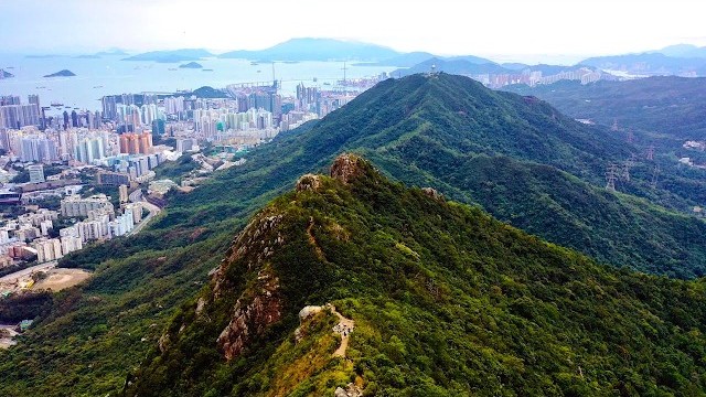
The MacLehose Trail film: Hong Kong

Hong Kong · 5 days · 71 miles

MacLehose Trail Hiking Guide

5 days across Hong Kong, from Sai Kung to Tuen Mun.

Watch the film · 345K views
Free sample
  • 345K YouTube views
  • Instant PDF + GPX
  • 30-day refund
  • Free updates

Look inside

Real pages from the guide. Tap one to see it big.
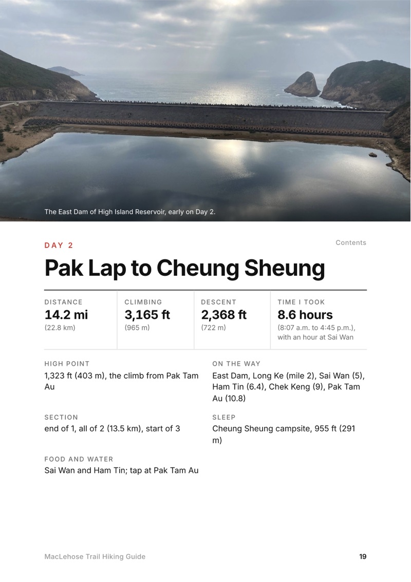
  • A day page page from the MacLehose Trail Hiking Guide
    A day page
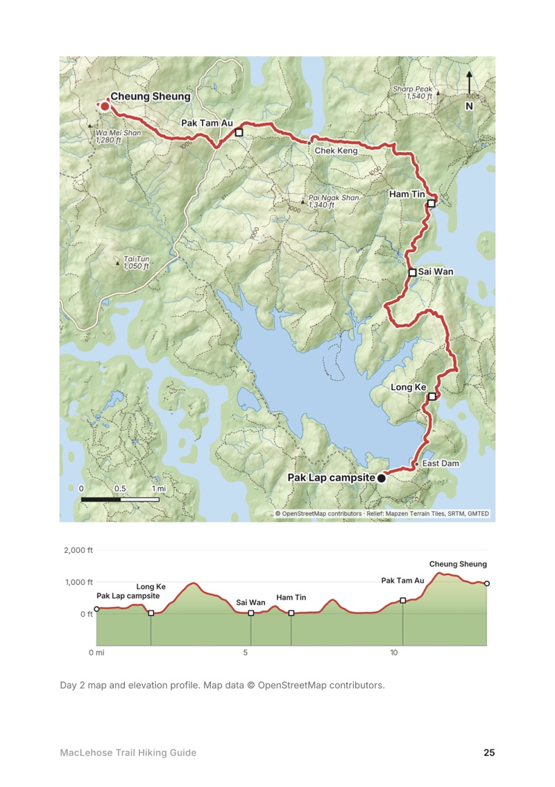
  • A day map and elevation profile page from the MacLehose Trail Hiking Guide
    A day map and elevation profile
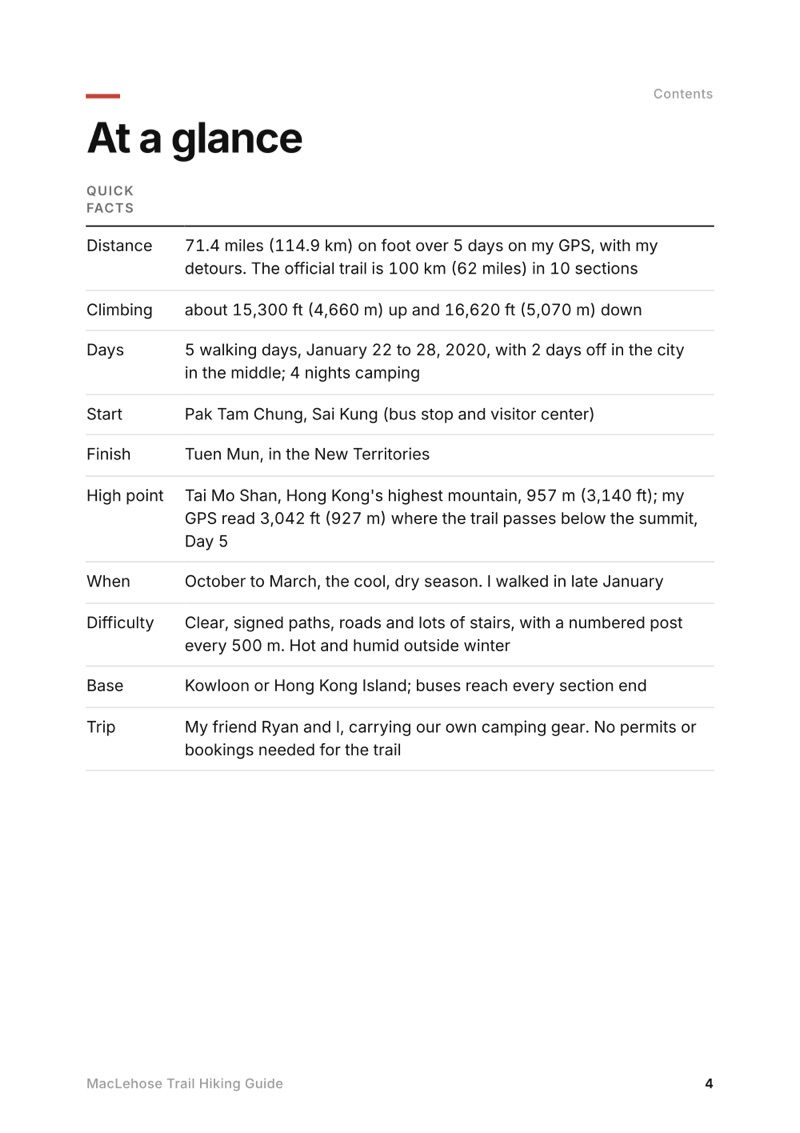
  • At a glance page from the MacLehose Trail Hiking Guide
    At a glance
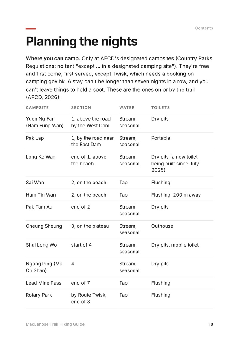
  • Planning the nights page from the MacLehose Trail Hiking Guide
    Planning the nights

Swipe for more pages

Get Day 2 free

The route

My GPS recording of 5 days on a relief map. The numbers are where each day starts; the red dot is the finish. The full GPX files and the day maps come with the guide.
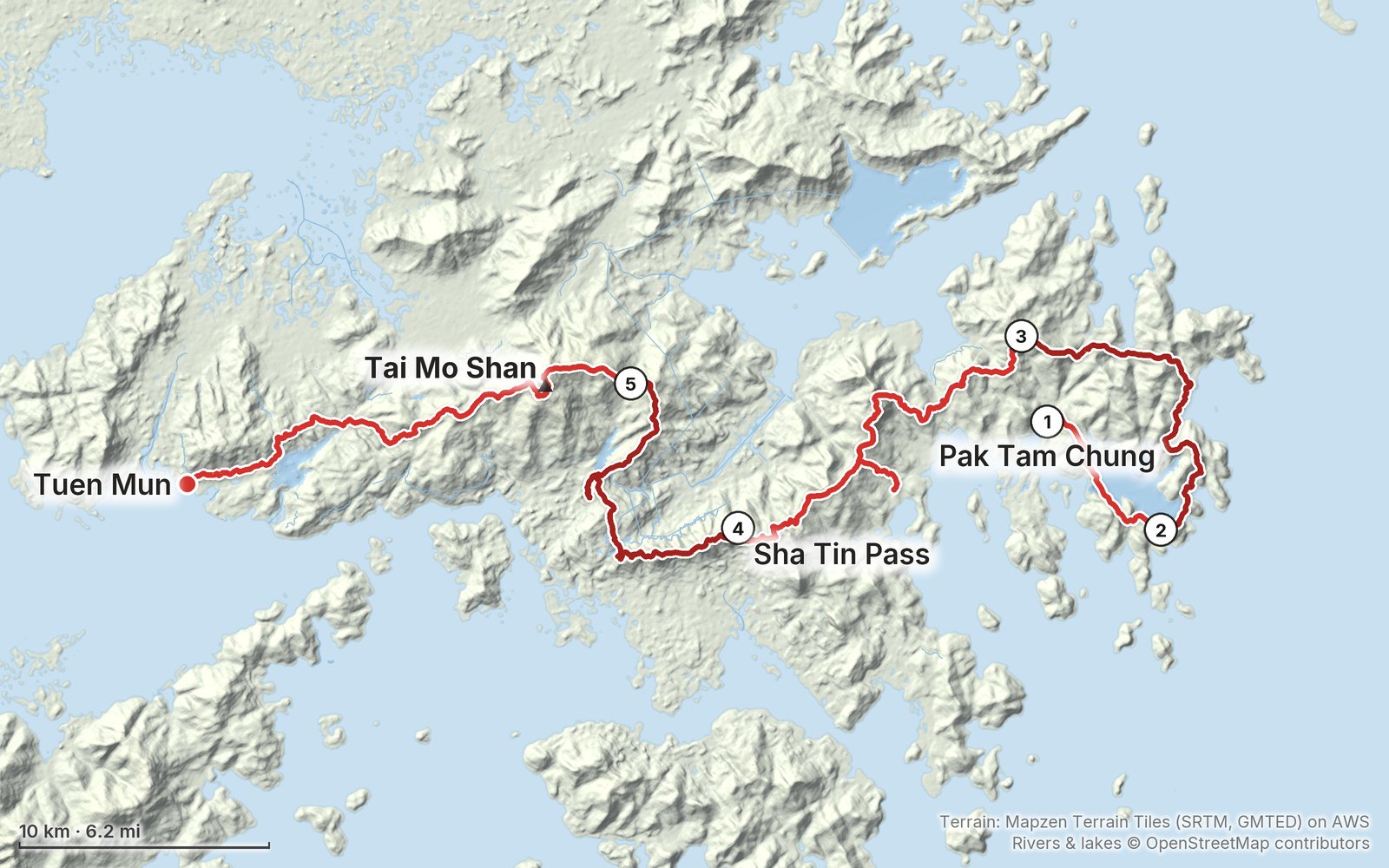
Relief map of the MacLehose Trail route: 5 days drawn in red with numbered day starts, labelled Pak Tam Chung, Tuen Mun, Tai Mo Shan and Sha Tin Pass.
1Day 2Day 3Day 4Day 5Highest 3,040 ft (927 m)

Elevation, start to finish: highest 3,040 ft (927 m), lowest sea level.

Map data: Terrain: Mapzen Terrain Tiles (SRTM, GMTED) on AWS · Rivers & lakes © OpenStreetMap contributors

At a glance

Days
5 days
Distance
71 miles
Climbing
About 15,300 ft (4,660 m) up
Season
October to March, the cool, dry season
Route
Pak Tam Chung to Tuen Mun

What's inside

  • All five days. Stats, the time I took, my notes, the trail, where to get off, a map with an elevation profile, and links to that day in my film.
  • My GPX files. My own recordings for each day, with waypoints for the campsites and places in the guide, ready for AllTrails, Gaia GPS, Garmin or Organic Maps.
  • Planning the nights. Every AFCD campsite on or by the trail with its water and toilets, the gap with no campsite, and how to sleep in the city instead.
  • Getting there and getting off. Buses to Pak Tam Chung, and the bus or minibus at every section end, checked in 2026.
  • Water and food. The filling stations, the village restaurants and stores, and the long dry stretches.
  • Safety. Heat, storms and warnings, the high-risk spots, monkeys and wild pigs, and the distance posts to give 999.
  • Before you go and a trip sheet. One page of year-to-year checks and a printable one-page summary of the whole trail.

About this trip

In January 2020 my friend Ryan and I hiked the whole MacLehose Trail across Hong Kong: from Pak Tam Chung around High Island Reservoir, along the beaches of Sai Kung, over Ma On Shan, Lion Rock and Tai Mo Shan to Tuen Mun, camping four nights. 71 miles on foot on my GPS. It's the trip from my film Hiking 60 miles on the MacLehose Trail in Hong Kong. This guide has my GPS files, maps and notes for every day, every official campsite on the route and where you can't camp, the buses at every section end, water, and what changed by 2026.

Watch the film on YouTube (345K views).

Gear for this route

Paid links: I earn a commission if you buy through these links, at no extra cost to you. As an Amazon Associate I earn from qualifying purchases.

My 2020 kit is from my film's original description and my photos. Here's what I carried, what I'd take now, and what I filmed with.

What I carried in 2020

From my film's gear list. Ryan and I carried our own camping gear; the list doesn't name a tent or a stove.

What I'd take now

What I'd add for this trail from my current kit.

Filming kit

What I filmed this trip with in 2020. My setup is much smaller now (below).

What I film with now

Since September 2026 I film with a smaller setup: the Pocket 4 and the Mic 3 on the trail, and the Mini 5 Pro in the air.

Everything I carry now: my gear page.

The Day 2, Pak Lap to Cheung Sheung page from the MacLehose Trail Hiking Guide

Free sample + packing list

Try Day 2 free, plus my packing list

Pak Lap to Cheung Sheung

The whole day page from the guide as a PDF, plus my camping packing list: the 42 things I carry, with a note on each. The PDF opens right away and both come by email. You'll also get my emails about new guides and trips, a few a year.

The details

Format
A 53-page PDF sized for a phone (A5, prints fine too) and a folder of GPX files, in one zip download.
Edition
2027 season edition, updated September 2026.
Delivery
Instant. After you pay you get a private download link. Bookmark it to download again on any device.
Payment
Secure checkout through Stripe, in your own currency. Tax is included in the price, except in the US and Canada, where any sales tax is added at checkout.
Refunds
Not useful? Email me within 30 days for a refund: kraig@kraigadams.com.
Questions
Email kraig@kraigadams.com.

Paying in the Facebook/Instagram app? Tap ⋯ and Open in browser to use Apple Pay or Google Pay.

$19

Questions

How many days does the MacLehose Trail take?
I walked it in 5 days in January 2020, with two days off in the city in the middle, camping four nights. The official trail is 100 km in 10 sections, and the parks department adds up to about 37 hours of walking. Many people walk it a section or two at a time from the city, because buses reach almost every section end.
Can you camp on the MacLehose Trail?
Yes, but only at the parks department's (AFCD) designated campsites, which are free. On or by the trail they include Pak Lap, Long Ke Wan, Sai Wan, Ham Tin Wan, Pak Tam Au, Cheung Sheung, Shui Long Wo, Ngong Ping, Lead Mine Pass, Rotary Park, Twisk, Ho Pui and Tin Fu Tsai. Twisk needs a booking. There is no campsite on Sections 5, 6 or 10.
Where does the MacLehose Trail start and finish?
It starts at Pak Tam Chung in Sai Kung, reached by bus 94 from Sai Kung town (and 96R and 289R on weekends and holidays), and finishes at Tuen Mun, near buses, the light rail and Tuen Mun MTR station.
Is there water on the MacLehose Trail?
Only in places. AFCD's filling stations are at Pak Tam Chung, Pak Tam Au, Sai Sha Road at Kei Ling Ha, Shing Mun and Kowloon Hill, and there are village restaurants at Sai Wan and Ham Tin. There are none on Sections 4, 5 or 7 to 10, so carry plenty and treat stream water.
When is the best time to hike the MacLehose Trail?
October to March, the cool and dry season. The Hong Kong Observatory calls November and December the best months of the year; May to September is hot, humid and rainy, with typhoons most likely from July to September. I went in late January.
How long is the MacLehose Trail?
100 km (62 miles) by the official sections. My GPS read 71.4 miles because of my detours: down to the Sai Kung road for Lunar New Year, up to the top of Lion Rock, and down to shops in Kwai Chung.

More guides

All guides
Mardi Himal, Annapurna region, Nepal

Annapurna region, Nepal

Mardi Himal

4 days · 32 miles · teahouse trek

Kande through Pothana, Forest Camp, Low Camp and High Camp to the ridge below Machapuchare, and down to Sidhing.
  • All four days
  • My GPX files
  • Permits and the guide rule
  • Getting there and home

See the guide: Mardi Himal · $19

Lantau Trail, Hong Kong

Hong Kong

Lantau Trail

4 days · 30.4 miles · Hong Kong

A 4-day hike on the Lantau Trail in Hong Kong, Sections 1 to 8: Mui Wo over Sunset Peak and Lantau Peak to Ngong Ping, then Tai O and the west coast to Shek Pik.

  • Where things stand
  • All four days
  • A plan for 2027
  • My GPX files

See the guide: Lantau Trail · $19

Get the next guide

I'm making guides for more of my hikes, and I host a group trip about once a year. Get an email when a new guide or trip is out. A few emails a year.

MacLehose Trail Hiking GuideInstant PDF + GPX