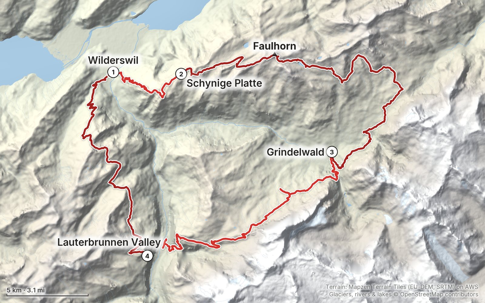
My GPS recording of 4 days on a relief map. The numbers are where each day starts; the red dot is the finish. The full GPX files and the day maps come with the guide.
1Day 2Day 3Day 4Highest 8,760 ft (2,671 m)
Elevation, start to finish: highest 8,760 ft (2,671 m), lowest 1,920 ft (584 m).
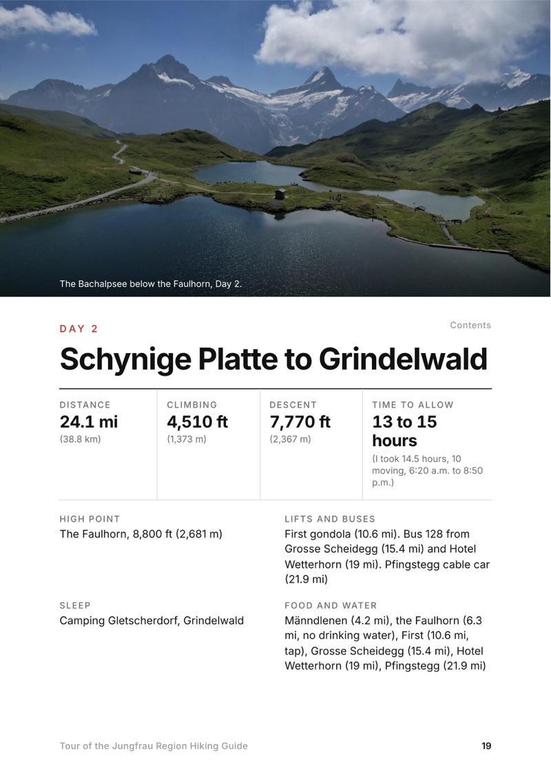
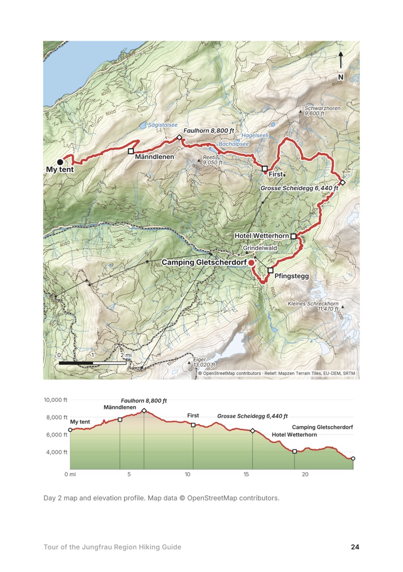
All four days. Stats, time to allow, my notes, the trail, where to get off, a map with an elevation profile, and links to that day in my film.
My GPX files. My own recordings for each day and the full loop, with waypoints for where I slept, the stations and lifts, the inns and the places I ate, ready for AllTrails, Gaia GPS, Garmin or Organic Maps.
Where to sleep. The two campsites I used, every mountain inn and hut on the loop with 2026 prices and seasons, and the camping rules in plain terms (my first camp wouldn't be allowed).
Trains, lifts and passes. The Schynige Platte railway, the First gondola, the Grosse Scheidegg bus, the Eiger Express and the Stechelberg cable car, with 2026 facts, and which pass is worth it.
Getting there. The trains from Zürich and Geneva and the lockers at Interlaken Ost, as I used them and with 2026 details.
Other ways to do it. A 7-day version with a bed every night, and shorter trips using the lifts.
What it cost. My 2022 receipts, and a do-it-yourself budget at 2026 prices.
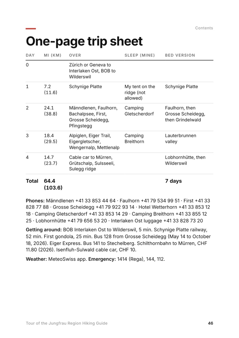
Before you go and a trip sheet. One page of year-to-year checks and a printable one-page summary of the whole loop.
About this trip
In July 2022 I hiked alone for four days on a loop through Switzerland's Jungfrau Region: about 64 miles from Wilderswil, near Interlaken, up to Schynige Platte, over the Faulhorn to First and Grindelwald, along the Eiger Trail under the north face, down into the Lauterbrunnen valley, and back over the hills from Mürren. This guide has my GPS files, maps and notes for every day, where to sleep and the camping rules, the trains, lifts and passes, and a 7-day version with a bed every night.
Paid links: I earn a commission if you buy through these links, at no extra cost to you. As an Amazon Associate I earn from qualifying purchases.
I camped all three nights on this loop, carrying everything myself. Here's what I carried in 2022, what I'd take now, and what I filmed with.
What I carried in 2022
I didn't list my kit for this trip. This is what the film and my photos show.
Tenta green one-person tent
Packa hiking pack
Shoestrail runners
Clothesa hooded top, and an orange insulated jacket in camp
What I'd take now
My current kit for this loop, with a bed or a tent. My favorite gear that year, from my Favorite Hiking Gear 2022 video (not a list of what I carried here): a Hyperlite Southwest 2400 pack, Nemo Hornet 1P tent, Hyperlite quilt, NeoAir XLite pad, Salomon Speedcross 5 and Brooks Cascadia 16 trail runners, Arc'teryx Beta AR, a Katadyn filter bottle, a Jetboil, a headlamp, an Anker power bank and a Sirui carbon tripod.
NavigationAllTrails+AllTrails · 30% offImport my GPX files and download them offline. Offline maps need the paid plan.
Phone dataAiralo eSIMAiralo · $3 offMobile data without a SIM swap. In 2022 I bought a Sunrise prepaid SIM in Zürich instead.
Filming kit
What I filmed this trip with in 2022. My setup is smaller now (below). Check the drone rules in Weather and safety before you fly: drones are prohibited in the hunting reserve around First.
The whole day page from the guide as a PDF, plus my camping packing list: the 42 things I carry, with a note on each, and this route's own list on top. The PDF opens right away and both come by email.
You'll also get my emails about new guides and trips, a few a year.
The details
Format
A 47-page PDF sized for a phone (A5, prints fine too) and a folder of GPX files, in one zip download.
Edition
2027 season edition, updated September 2026.
Delivery
Instant. After you pay you get a private download link. Bookmark it to download again on any device.
Payment
Secure checkout through Stripe, in your own currency. Tax is included in the price, except in the US and Canada, where any sales tax is added at checkout.
How many days do you need for the Tour of the Jungfrau Region?
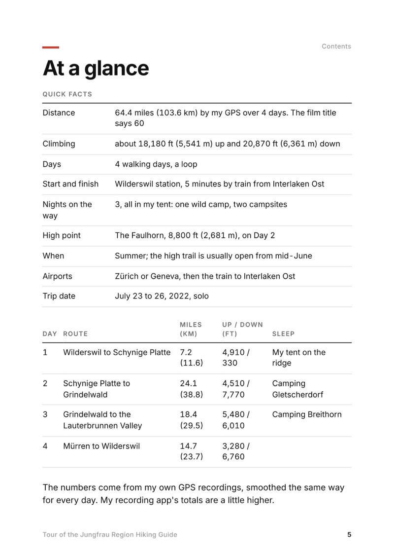
I did the loop in four days in July 2022, about 64 miles. With a bed every night it's a comfortable seven, and the trains and lifts let you cut almost any day short.
When is the best time to hike the Jungfrau Region?
Summer. The high trail over the Faulhorn is usually open from mid-June, and July to the end of September is the easiest window. I went July 23 to 26, 2022, and there was still a patch of snow below the Faulhorn summit.
Where do you sleep on the Tour of the Jungfrau Region?
I camped at Camping Gletscherdorf in Grindelwald and Camping Breithorn in the Lauterbrunnen valley. There are mountain inns along the high part of the loop, like the Berghotel Faulhorn and Grosse Scheidegg. Wild camping is banned in Bönigen, Grindelwald and Lauterbrunnen.
How do you get to the start at Wilderswil?
Take the train to Interlaken Ost: about 1 hour 55 minutes from Zürich, or about 3 hours from Geneva, changing in Bern. From Interlaken Ost the BOB train to Wilderswil takes 5 minutes. I left my big bag in a locker at Interlaken Ost.
Do you need to book anything?
I didn't book anything for the hike itself. The mountain inns are small, so book those ahead in July and August. Camping Gletscherdorf takes bookings for its tent meadow online.
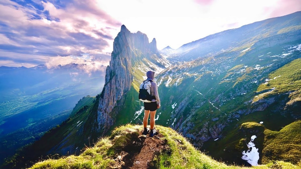
A 2-day hike in the Alpstein, Appenzell, Switzerland: from Wasserauen past the Seealpsee to the Berggasthaus Schäfler, then over the Widderalpsattel and the Saxer Lücke to the Staubern cable car.